HP iPAQ 614c HP iPAQ Trip Guide (UK) - Page 120
Glossary
 |
View all HP iPAQ 614c manuals
Add to My Manuals
Save this manual to your list of manuals |
Page 120 highlights
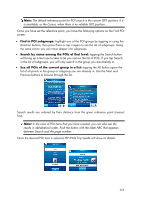
Glossary The manual may contain many technical terms. Please look below for an explanation if you are unfamiliar with some of them. 2D/3D GPS reception: The GPS receiver uses satellite signals to calculate its (your) position. Depending on the current positions of the ever moving satellites in the sky, and the objects in your environment, the signal that your GPS device receives may be weaker or stronger. Your GPS needs strong signal from at least four satellites to give a three dimensional position including elevation. If fewer satellites are available, it may still be possible to calculate the position but the accuracy will be lower and the GPS device will not calculate elevation. This is called 2D reception. HP iPAQ Trip Guide shows the quality of reception on the Main menu (Page 22), the GPS Data screen (Page 36) and both map screens (Page 45). Note that 2D and 3D GPS receptions have nothing to do with the 2D and 3D display modes of the map. That is a way of representing the map on the screen independently from the GPS reception. Accuracy: The difference between your real position and the one given by the GPS device is affected by several different factors. The GPS is capable of providing a guess of its current error based on the number of satellites it can receive a signal from, and their position in the sky. This information is shown in HP iPAQ Trip Guide on the GPS Data screen (Page 36). Use it as a general reference only. Note that several other factors affect the real accuracy, some of which the GPS is incapable of estimating (e.g. signal delay in the ionosphere, reflecting objects near the GPS device, etc.). Active route: A route is an itinerary planned to reach your chosen destinations. A route is active when it is used for navigation. HP iPAQ Trip Guide has only one route at a time, and it is always active until you delete it, reach the final destination or exit HP iPAQ Trip Guide. When there is more than one destination to reach, the route is cut into different legs (from one via point to another). Only one of these legs can be active at one particular time. The rest of them are unused and shown in a different colour on the map. 120
-
 1
1 -
2
-
3
-
4
-
5
-
6
-
7
-
8
-
9
-
10
-
11
-
12
-
13
-
14
-
15
-
16
-
17
-
18
-
19
-
20
-
21
-
22
-
23
-
24
-
25
-
26
-
27
-
28
-
29
-
30
-
31
-
32
-
33
-
34
-
35
-
36
-
37
-
38
-
39
-
40
-
41
-
42
-
43
-
44
-
45
-
46
-
47
-
48
-
49
-
50
-
51
-
52
-
53
-
54
-
55
-
56
-
57
-
58
-
59
-
60
-
61
-
62
-
63
-
64
-
65
-
66
-
67
-
68
-
69
-
70
-
71
-
72
-
73
-
74
-
75
-
76
-
77
-
78
-
79
-
80
-
81
-
82
-
83
-
84
-
85
-
86
-
87
-
88
-
89
-
90
-
91
-
92
-
93
-
94
-
95
-
96
-
97
-
98
-
99
-
100
-
101
-
102
-
103
-
104
-
105
-
106
-
107
-
108
-
109
-
110
-
111
-
112
-
113
-
114
-
 115
115 -
 116
116 -
 117
117 -
 118
118 -
 119
119 -
 120
120 -
 121
121 -
 122
122 -
 123
123 -
 124
124 -
 125
125 -
126
-
127
-
128
 |
 |