HP iPAQ 614c HP iPAQ Trip Guide (UK) - Page 27
Streets and roads
 |
View all HP iPAQ 614c manuals
Add to My Manuals
Save this manual to your list of manuals |
Page 27 highlights
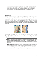
Note: The colours mentioned and screenshots included in this manual refer to the default daytime and night colour schemes. They may not look the same in the schemes you have chosen. Tip: If you use HP iPAQ Trip Guide after sunrise or before sunset, look for the sun in the sky in the map background using a flat 3D view. It is displayed at its actual position to give you another way to orientate, and also to provide some eye candy. Streets and roads The similarity of HP iPAQ Trip Guide to paper roadmaps is also convenient when it comes to streets, the most important elements of the map concerning navigation. HP iPAQ Trip Guide uses similar colour codes to those you are accustomed to, and the width of the streets also refers to their importance, so it will not be difficult to tell a highway from a small street. Streets and roads have names or numbers for identification. Of course, this information can be displayed on the map. HP iPAQ Trip Guide uses two different ways to show street labels. The conventional way is the same as a roadmap - it displays the name of the street aligned with the street. The alternative is a kind of virtual signpost stuck into the street itself. 27
-
 1
1 -
2
-
3
-
4
-
5
-
6
-
7
-
8
-
9
-
10
-
11
-
12
-
13
-
14
-
15
-
16
-
17
-
18
-
19
-
20
-
21
-
 22
22 -
 23
23 -
 24
24 -
 25
25 -
 26
26 -
 27
27 -
 28
28 -
 29
29 -
 30
30 -
 31
31 -
 32
32 -
33
-
34
-
35
-
36
-
37
-
38
-
39
-
40
-
41
-
42
-
43
-
44
-
45
-
46
-
47
-
48
-
49
-
50
-
51
-
52
-
53
-
54
-
55
-
56
-
57
-
58
-
59
-
60
-
61
-
62
-
63
-
64
-
65
-
66
-
67
-
68
-
69
-
70
-
71
-
72
-
73
-
74
-
75
-
76
-
77
-
78
-
79
-
80
-
81
-
82
-
83
-
84
-
85
-
86
-
87
-
88
-
89
-
90
-
91
-
92
-
93
-
94
-
95
-
96
-
97
-
98
-
99
-
100
-
101
-
102
-
103
-
104
-
105
-
106
-
107
-
108
-
109
-
110
-
111
-
112
-
113
-
114
-
115
-
116
-
117
-
118
-
119
-
120
-
121
-
122
-
123
-
124
-
125
-
126
-
127
-
128
 |
 |
