HP Color LaserJet Enterprise CP4020 HP Designjet 4020 and 4520 Printer Series - Page 93
and Print Setup, Print Quality, Print In Grayscale, Color, Matching Method, Print, Printer Engine
 |
View all HP Color LaserJet Enterprise CP4020 manuals
Add to My Manuals
Save this manual to your list of manuals |
Page 93 highlights
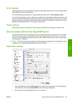
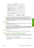
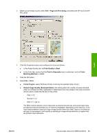
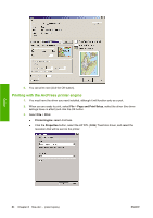
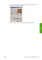
2. When you are ready to print, select File > Page and Print Setup, and select the HP-GL/2 and HP RTL driver. Color 3. Click the Properties button and configure the driver as follows. ● In the Paper/Quality tab, set Print Quality to Best. ● In the Color tab, ensure that the Print In Grayscale box is unchecked, and set Color Matching Method to 'sRGB'. 4. Click the OK button. 5. Select File > Print. ● Printer Engine: select Windows Printer (it will use the selected raster driver). ● Output Image Quality (Resample Ratio): this setting alters the number of pixels sampled when an ArcMap print file is generated; it determines how many pixels in the map document will be used to create the file sent to the printer. ◦ Fast = 1:5 ◦ Normal = 1:3 ◦ Best = 1:1 (as is) The 'Best' choice requires a lot of resources to process the print job, and could cause long processing times and perhaps out-of-memory messages, depending on the map size. If you have these problems, select an Output Image Quality lower than 'Best'. Bear in mind that you will gain no advantage in print quality by sending an image whose resolution is higher than the printer's input resolution. ENWW Get accurate colors from ESRI ArcGIS 9 83
-
 1
1 -
2
-
3
-
4
-
5
-
6
-
7
-
8
-
9
-
10
-
11
-
12
-
13
-
14
-
15
-
16
-
17
-
18
-
19
-
20
-
21
-
22
-
23
-
24
-
25
-
26
-
27
-
28
-
29
-
30
-
31
-
32
-
33
-
34
-
35
-
36
-
37
-
38
-
39
-
40
-
41
-
42
-
43
-
44
-
45
-
46
-
47
-
48
-
49
-
50
-
51
-
52
-
53
-
54
-
55
-
56
-
57
-
58
-
59
-
60
-
61
-
62
-
63
-
64
-
65
-
66
-
67
-
68
-
69
-
70
-
71
-
72
-
73
-
74
-
75
-
76
-
77
-
78
-
79
-
80
-
81
-
82
-
83
-
84
-
85
-
86
-
87
-
 88
88 -
 89
89 -
 90
90 -
 91
91 -
 92
92 -
 93
93 -
 94
94 -
 95
95 -
 96
96 -
 97
97 -
 98
98 -
99
-
100
-
101
-
102
-
103
-
104
-
105
-
106
-
107
-
108
-
109
-
110
-
111
-
112
-
113
-
114
-
115
-
116
-
117
-
118
-
119
-
120
-
121
-
122
-
123
-
124
-
125
-
126
-
127
-
128
-
129
-
130
-
131
-
132
-
133
-
134
-
135
-
136
-
137
-
138
-
139
-
140
-
141
-
142
-
143
-
144
-
145
-
146
-
147
-
148
-
149
-
150
-
151
-
152
-
153
-
154
-
155
-
156
-
157
-
158
-
159
-
160
-
161
-
162
-
163
-
164
-
165
-
166
-
167
-
168
-
169
-
170
-
171
-
172
-
173
-
174
-
175
-
176
-
177
-
178
-
179
-
180
-
181
-
182
-
183
-
184
-
185
-
186
-
187
-
188
-
189
-
190
-
191
-
192
-
193
-
194
-
195
-
196
-
197
-
198
-
199
-
200
-
201
-
202
-
203
-
204
-
205
-
206
-
207
-
208
-
209
-
210
-
211
-
212
-
213
-
214
-
215
-
216
-
217
-
218
-
219
-
220
-
221
-
222
-
223
-
224
-
225
-
226
-
227
-
228
-
229
-
230
-
231
-
232
-
233
-
234
-
235
 |
 |
