Nokia C6-00 Nokia C6-00 User Guide in US English - Page 67
Indicator area
 |
View all Nokia C6-00 manuals
Add to My Manuals
Save this manual to your list of manuals |
Page 67 highlights
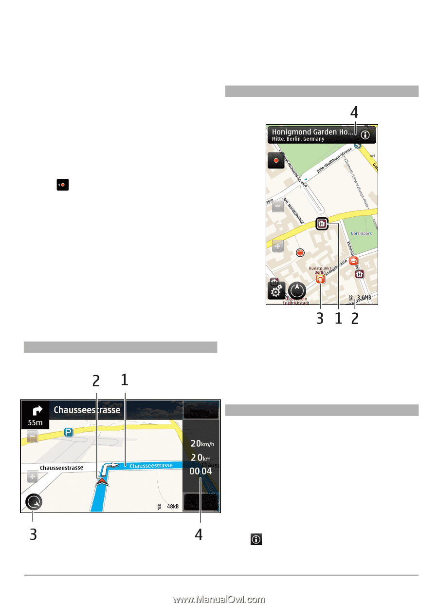
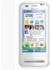
If only cell ID based positioning is available, a red halo around the positioning icon indicates the general area you might be in. In densely populated areas, the accuracy of the estimate increases, and the red halo is smaller than in lightly populated areas. Move on the map Drag the map with your finger. By default, the map is oriented north. View your current or last known location Select . 2 Your location and direction 3 Compass 4 Information bar (speed, distance, time) Map view Zoom in or out. Select + or -. If you browse to an area not covered by the maps that are stored on your device and you have an active data connection, new maps are automatically downloaded. Map coverage varies by country and region. Navigation view 1 Selected location 2 Indicator area 3 Point of interest (for example, a railway station or a museum) 4 Information area Plan a route Plan your journey, and create your route and view it on the map before setting off. Select Menu > Maps and My position. 1 Route Create a route 1 Tap the location of your starting point. To search for an address or place, select Search. 2 Tap the location's information area ( ). 3 Select Add to route. © 2010 Nokia. All rights reserved. 67
-
 1
1 -
2
-
3
-
4
-
5
-
6
-
7
-
8
-
9
-
10
-
11
-
12
-
13
-
14
-
15
-
16
-
17
-
18
-
19
-
20
-
21
-
22
-
23
-
24
-
25
-
26
-
27
-
28
-
29
-
30
-
31
-
32
-
33
-
34
-
35
-
36
-
37
-
38
-
39
-
40
-
41
-
42
-
43
-
44
-
45
-
46
-
47
-
48
-
49
-
50
-
51
-
52
-
53
-
54
-
55
-
56
-
57
-
58
-
59
-
60
-
61
-
 62
62 -
 63
63 -
 64
64 -
 65
65 -
 66
66 -
 67
67 -
 68
68 -
 69
69 -
 70
70 -
 71
71 -
 72
72 -
73
-
74
-
75
-
76
-
77
-
78
-
79
-
80
-
81
-
82
-
83
-
84
-
85
-
86
-
87
-
88
-
89
-
90
-
91
-
92
-
93
-
94
-
95
-
96
-
97
-
98
-
99
-
100
-
101
-
102
-
103
-
104
-
105
-
106
-
107
-
108
-
109
-
110
-
111
-
112
-
113
-
114
-
115
-
116
-
117
 |
 |