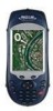
Magellan MobileMapper CX Getting Started Guide - Page 22
Setting Up GPS Positioning, Programs>GPS Utilities>GPS Settings, Open Sky, Tree Canopy - accuracy
 |
UPC - 009905860047
View all Magellan MobileMapper CX manuals
Add to My Manuals
Save this manual to your list of manuals |
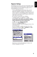
Page 22 highlights
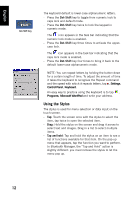
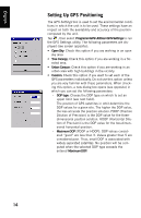
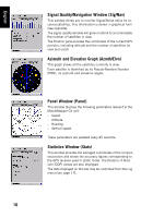
English Setting Up GPS Positioning The GPS Settings tool is used to set the environmental conditions in which the unit is to be used. These settings have an impact on both the availability and accuracy of the position computed by the unit. Tap , then select Programs>GPS Utilities>GPS Settings to run the GPS Settings utility. The following parameters are displayed (see screen opposite): • Open Sky: Check this option if you are working in an open sky area. • Tree Canopy: Check this option if you are working in a for- ested area. • Urban Canyon: Check this option if you are working in an urban area with high buildings in the vicinity. • Custom: Check this option if you want to set each of the GPS parameters individually. Do not use this option unless you are very familiar with these parameters. When checking this option, a new dialog box opens (see opposite) in which you can set the following parameters: - DOP type: Choose the DOP type on which to set an upper limit (see next field). The position of GPS satellites in orbit determine the DOP values for a given site. The higher the DOP value, the less accurate the position solution. PDOP (Position Dilution of Precision) is the DOP value for the threedimensional position solution. HDOP (Horizontal Dilution of Precision) is the DOP value for the two-dimensional horizontal position. - Maximum DOP [PDOP or HDOP]: DOP values considered "good" are less than 3. Values greater than 5 are considered poor. Thus, small DOP is associated with widely separated satellites. No position will be computed when the selected DOP type exceeds the entered Maximum DOP. 14
-
 1
1 -
2
-
3
-
4
-
5
-
6
-
7
-
8
-
9
-
10
-
11
-
12
-
13
-
14
-
15
-
16
-
 17
17 -
 18
18 -
 19
19 -
 20
20 -
 21
21 -
 22
22 -
 23
23 -
 24
24 -
 25
25 -
 26
26 -
 27
27 -
28
-
29
-
30
-
31
-
32
-
33
-
34
-
35
-
36
-
37
-
38
-
39
-
40
-
41
-
42
-
43
-
44
-
45
-
46
-
47
-
48
-
49
-
50
-
51
-
52
-
53
-
54
-
55
-
56
-
57
-
58
-
59
-
60
-
61
-
62
-
63
-
64
-
65
-
66
-
67
-
68
-
69
-
70
-
71
-
72
-
73
-
74
-
75
-
76
-
77
-
78
-
79
-
80
-
81
-
82
-
83
-
84
-
85
-
86
 |
 |
