Kenwood TH-D75 User Manual - Page 56
Displaying Position Information, Built-in GPS Operation Mode, Key Operation in GPS Receiver Mode
 |
View all Kenwood TH-D75 manuals
Add to My Manuals
Save this manual to your list of manuals |
Page 56 highlights
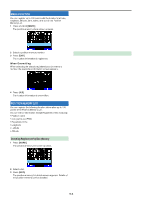
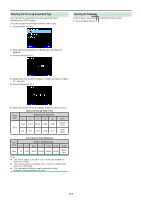
Displaying Position Information When the built-in GPS receiver is On, pressing [F], [MARK] will display "Latitude/longitude, time, altitude, heading, speed", then press [ ] to cycle the display between "Latitude/ longitude, time, altitude, heading, speed" "Target point distance, Travel direction" "GPS satellite information". • Press [ ] returns to the previous display. Latitude/longitude, Time, Altitude, Heading, Speed ① ② ③ ④ ⑥ ⑤ ⑦ ① Latitude ② Longitude ③ Grid square locator ④ Altitude ⑤ Time ⑥ Heading ⑦ Speed Target point distance, Target direction Built-in GPS Operation Mode 1 Access Menu No. 403. 2 Select [Normal] or [GPS Receiver]. 3 Press [A/B] to restart the transceiver with the selected mode. [Normal]: The display continues to show your frequency. You can use it as a normal transceiver. [GPS Receiver]: The display shows only GPS information. The transceiver transmit and receive capabilities are turned OFF, and only GPS operation is available. GPS Receiver mode display ① ② ① Target direction ② Target point distance • When pressing [F] while the target point distance/ target direction is displayed, the North Up display (displays North as the top) changes to the Heading Up display (displays the current travel direction as the top) or vice-versa. In the Heading Up display, a "+" or "-" is used to help indicate the traveling direction. GPS satellite information ③ ① ② ① Sky view ② Satellite signal-strength bars ③ 2D: Latitude/Longitude positioning 3D: Latitude/Longitude and Altitude positioning • The sky view shows the satellites you are receiving. The satellite signal-strength bars indicate the strength of each satellite you are receiving. A solid bar indicates that the GPS satellite is ready for use. • When only the frame of the signal-strength bar is displayed, no contact with the satellite has yet been made Note: ¡ When GPS cannot be received, turn the power ON in a clear environment (Open Sky). Key Operation in GPS Receiver Mode When set to [GPS Receiver], you can operate only the following key functions. Key operations in [Latitude/longitude, Time, Altitude, Heading, Speed] Key Name [] [] [MODE] [MENU] [A/B] [F] [MARK] Operation Switches to FM radio frequency screen when FM radio mode is On. Switches to [Target point distance and Heading] screen. Switches to [Latitude and Longitude] copy selection screen. Switches to the menu screen. Switches to [Time] copy confirmation screen. Switches between the North up and the Heading up. Press [MARK]: Switches Mark waypoint list. Press and hold [MARK]: Switches to the registration mode of mark position. Key operations in [Target point distance, Target direction] Key Name [] [] [MODE] [MENU] [A/B] [F] Operation Switches to [Time, Altitude, Heading, and Speed] screen. Switches to [GPS satellite information] screen. Switches to [Time, Altitude, Heading, and Speed] screen. Switches to the menu screen. Switches to [GPS satellite information] screen. Switches between the North up and the Heading up. [MARK] Press and hold [MARK]: Switches to the registration mode of mark position. 13-2
-
 1
1 -
2
-
3
-
4
-
5
-
6
-
7
-
8
-
9
-
10
-
11
-
12
-
13
-
14
-
15
-
16
-
17
-
18
-
19
-
20
-
21
-
22
-
23
-
24
-
25
-
26
-
27
-
28
-
29
-
30
-
31
-
32
-
33
-
34
-
35
-
36
-
37
-
38
-
39
-
40
-
41
-
42
-
43
-
44
-
45
-
46
-
47
-
48
-
49
-
50
-
 51
51 -
 52
52 -
 53
53 -
 54
54 -
 55
55 -
 56
56 -
 57
57 -
 58
58 -
 59
59 -
 60
60 -
 61
61 -
62
-
63
-
64
-
65
-
66
-
67
-
68
-
69
-
70
-
71
-
72
-
73
-
74
-
75
-
76
-
77
-
78
-
79
-
80
-
81
-
82
-
83
-
84
-
85
-
86
-
87
-
88
-
89
-
90
-
91
-
92
-
93
-
94
-
95
-
96
-
97
-
98
-
99
-
100
-
101
-
102
-
103
-
104
-
105
-
106
-
107
-
108
-
109
-
110
-
111
-
112
-
113
-
114
-
115
-
116
-
117
-
118
-
119
-
120
-
121
-
122
-
123
-
124
-
125
-
126
-
127
-
128
-
129
-
130
-
131
-
132
-
133
 |
 |
