Nextar Q4-MD User Manual - Page 16
More information, Status - battery
 |
UPC - 714129929912
View all Nextar Q4-MD manuals
Add to My Manuals
Save this manual to your list of manuals |
Page 16 highlights
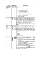
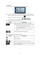
The following information can be seen in the three data fields shown on the map screen. Tap this area to open the Trip Information screen where you can select which values to be shown in these three fields. When there is no active route, these fields show the following information: current speed, compass and the current time of day. Icon Type Compass More information Shows the direction of your heading both when the map is automatically rotated (3D) and when the map is always facing North (2D). Speed information There are speed values that can be shown: • Current speed • Speed limit on the current road Time information There are time values that can be shown: • Current GPS time • Time remaining to reach the destination • Time remaining to reach the next via point • Estimated arrival time at the destination • Estimated arrival time at the next via point Distance information There are distance type values that can be shown: • Distance remaining to reach the destination • Distance remaining to reach the next via point • Current altitude The next area is a combined status indicator field. Tap this area to open the Quick menu (page 64). Icon Status for More information GPS position quality A higher number of lit bars indicates better GPS position accuracy. Battery status The device is running on battery power. The number of lit bars represent the remaining capacity. The battery is being charged The device charged. is running on external power. The battery is being Vehicle type The symbol displays the vehicle type used for route calculation. 17
-
 1
1 -
2
-
3
-
4
-
5
-
6
-
7
-
8
-
9
-
10
-
 11
11 -
 12
12 -
 13
13 -
 14
14 -
 15
15 -
 16
16 -
 17
17 -
 18
18 -
 19
19 -
 20
20 -
 21
21 -
22
-
23
-
24
-
25
-
26
-
27
-
28
-
29
-
30
-
31
-
32
-
33
-
34
-
35
-
36
-
37
-
38
-
39
-
40
-
41
-
42
-
43
-
44
-
45
-
46
-
47
-
48
-
49
-
50
-
51
-
52
-
53
-
54
-
55
-
56
-
57
-
58
-
59
-
60
-
61
-
62
-
63
-
64
-
65
-
66
-
67
-
68
-
69
-
70
-
71
-
72
-
73
-
74
-
75
-
76
-
77
-
78
-
79
-
80
-
81
-
82
-
83
-
84
-
85
 |
 |
