Nextar Q4-MD User Manual - Page 19
Daytime and night color profiles
 |
UPC - 714129929912
View all Nextar Q4-MD manuals
Add to My Manuals
Save this manual to your list of manuals |
Page 19 highlights
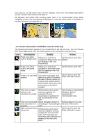
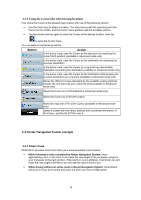
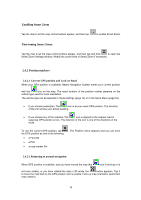
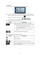
Note! Even if you move the map while you are driving, Nextar Navigation System continues navigating if there is an active route: it plays the voice instructions and displays the turn preview icons according to your current GPS position. 2.4.2.3 Selected location (Cursor) If you select a location in the Find menu, or you tap the map when the map control buttons are visible, the Cursor appears at the selected point on the map. Nextar Navigation System displays the Cursor with a radiating red dot ( ) to make it visible at all zoom levels, even when it is in the background of a 3D map view. When the Cursor is set, tap one of the following: . The Cursor menu appears and you can use the Cursor as • the start point of a route • a via point in a route • the destination of a route You can also search for POIs around the Cursor. Or you can save the location of the Cursor as: • a Favorite • a POI • a map marker Pin 2.4.2.4 Original position in the Cursor menu When the Cursor menu is open, a special icon ( was opened with. ) shows the Cursor position the menu You can move and zoom the map, and you can set the Cursor to a different place. The usual Cursor ( location. ) appears, and the buttons of the Cursor menu initiate actions for this new To return to the original Cursor position, tap which the Cursor menu was opened, and the . The map jumps back to the position with icon appears again. 2.4.3 Daytime and night color profiles Nextar Navigation System uses different color profiles during the day and during the night. • Daytime colors are similar to paper road maps. • The night color profiles use dark colors for large objects to keep the average brightness of the screen low. Nextar Navigation System offers different daytime and night color profiles. It can also switch automatically between the daytime and the night scheme based on the current time and GPS 20
-
 1
1 -
2
-
3
-
4
-
5
-
6
-
7
-
8
-
9
-
10
-
11
-
12
-
13
-
 14
14 -
 15
15 -
 16
16 -
 17
17 -
 18
18 -
 19
19 -
 20
20 -
 21
21 -
 22
22 -
 23
23 -
 24
24 -
25
-
26
-
27
-
28
-
29
-
30
-
31
-
32
-
33
-
34
-
35
-
36
-
37
-
38
-
39
-
40
-
41
-
42
-
43
-
44
-
45
-
46
-
47
-
48
-
49
-
50
-
51
-
52
-
53
-
54
-
55
-
56
-
57
-
58
-
59
-
60
-
61
-
62
-
63
-
64
-
65
-
66
-
67
-
68
-
69
-
70
-
71
-
72
-
73
-
74
-
75
-
76
-
77
-
78
-
79
-
80
-
81
-
82
-
83
-
84
-
85
 |
 |
