Nextar Q4-MD User Manual - Page 57
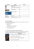
Symbol, Description
 |
UPC - 714129929912
View all Nextar Q4-MD manuals
Add to My Manuals
Save this manual to your list of manuals |
Page 57 highlights
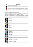
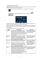
Symbol Name Cursor (selected location) Description map The location selected in the Find menu, point selected by tapping the map. or a map Start point The first point of the route. Normally if GPS position is available, it is the start point of the route. If there is no valid GPS position, Nextar Navigation System uses the last known GPS position as the start point. When you are using a saved route, Nextar Navigation System asks you if you want to use your GPS position or the first point in the saved route as the start point. You can also modify the start point in the Cursor menu. If you do so, automatic off-route recalculation needs to be turned off to keep the selected point as the start point. If automatic off-route recalculation is disabled for Via point any of the above, tapping the icon in the Turn Preview field not only initiates route recalculation from the current GPS position, but it will re-enable the automatic off-route recalculation as well. A via point is an intermediate destination. You can place as many via points as you want. Destination (end point) The last point of the route, the final destination. Route color Active leg of the route The route always stands out with its color on the map, both in daytime and in night color mode. The active leg of the route is always displayed in a brighter shade than the inactive (upcoming) legs. The section of the route on which you are driving. If you have not added any via points (only a destination), the entire route is the active leg. If you have added via points, the active leg is the part of the route from your current location to the next route point (the next via point, or the destination if there are no more via points to reach). Inactive legs of the route The future sections of the route; each of them becomes active when you reach the via point at its beginning. Streets and roads that are You can choose whether you want to use or avoid excluded from the navigation certain road types (page 74). However, when Nextar Navigation System cannot avoid such roads, the route will include them and it will show them in a color that is different from the route color. 58
-
 1
1 -
2
-
3
-
4
-
5
-
6
-
7
-
8
-
9
-
10
-
11
-
12
-
13
-
14
-
15
-
16
-
17
-
18
-
19
-
20
-
21
-
22
-
23
-
24
-
25
-
26
-
27
-
28
-
29
-
30
-
31
-
32
-
33
-
34
-
35
-
36
-
37
-
38
-
39
-
40
-
41
-
42
-
43
-
44
-
45
-
46
-
47
-
48
-
49
-
50
-
51
-
 52
52 -
 53
53 -
 54
54 -
 55
55 -
 56
56 -
 57
57 -
 58
58 -
 59
59 -
 60
60 -
 61
61 -
 62
62 -
63
-
64
-
65
-
66
-
67
-
68
-
69
-
70
-
71
-
72
-
73
-
74
-
75
-
76
-
77
-
78
-
79
-
80
-
81
-
82
-
83
-
84
-
85
 |
 |