Nextar Q4-MD User Manual - Page 72
Button, Description, Reference
 |
UPC - 714129929912
View all Nextar Q4-MD manuals
Add to My Manuals
Save this manual to your list of manuals |
Page 72 highlights
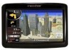
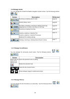
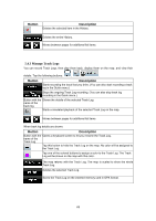
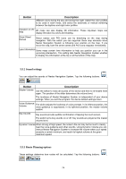
Button Description Reference These settings allow you to customize the application for your page 76 local language, measurement units, time and date settings and formats, as well as to choose the voice guidance profile you prefer. You can control how Nextar Navigation System behaves page 77 during navigation. You can enable some useful warnings, and disable the touch page 78 screen in a moving vehicle with Safety Mode. You can set up the connection to the GPS receiver. page 79 You can modify the look and behavior of the Menu screens. page 79 You can change some device settings to control the screen page 79 backlight when Nextar Navigation System is running. You can set up automatic Track Log saving and fine-tune page 80 related settings. This screen has no navigation feature. It merely provides information about the maps and licenses included with your navigation system. You can switch to Simple mode. In Simple mode only a few of page 9 the above settings are available. The rest of the settings are set to values that are optimal for typical use. 5.5.1 Map Screen settings You can fine-tune the appearance and content of the Map screen. Tap the following buttons: , , Button 3D Settings Color Profiles . Description Use 3D settings to determine which of the present 3D objects are shown on the map, and adjust the level of 3D visual detail. The options are as follows: • Landmarks: Landmarks are 3D artistic or block representations of prominent or well-known objects. 3D landmarks are only available in selected cities and countries. • Elevated Roads: Complex intersections and vertically isolated roads (such as overpasses or underground tunnels) are displayed in 3D. • Building Visibility: Full 3D city building data that represents actual building size and position on the map. Building data is limited to the city centers of major cities in the US and Europe. • Terrain Detail Level: 3D terrain map data shows changes in terrain, elevations or depressions in the land when you view the map, and use it to plot the route map in 3D when you navigate. Nextar Navigation System is able to show the map and the menus in 73
-
 1
1 -
2
-
3
-
4
-
5
-
6
-
7
-
8
-
9
-
10
-
11
-
12
-
13
-
14
-
15
-
16
-
17
-
18
-
19
-
20
-
21
-
22
-
23
-
24
-
25
-
26
-
27
-
28
-
29
-
30
-
31
-
32
-
33
-
34
-
35
-
36
-
37
-
38
-
39
-
40
-
41
-
42
-
43
-
44
-
45
-
46
-
47
-
48
-
49
-
50
-
51
-
52
-
53
-
54
-
55
-
56
-
57
-
58
-
59
-
60
-
61
-
62
-
63
-
64
-
65
-
66
-
 67
67 -
 68
68 -
 69
69 -
 70
70 -
 71
71 -
 72
72 -
 73
73 -
 74
74 -
 75
75 -
 76
76 -
 77
77 -
78
-
79
-
80
-
81
-
82
-
83
-
84
-
85
 |
 |