Nextar Q4-MD User Manual - Page 65
Find menu
 |
UPC - 714129929912
View all Nextar Q4-MD manuals
Add to My Manuals
Save this manual to your list of manuals |
Page 65 highlights
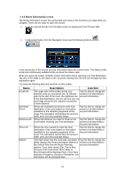
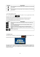
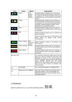
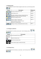
Icon Color Green Yellow Gray Red Name GPS position quality indicator Description Nextar Navigation System has a connection to the GPS receiver and GPS position information is available in 3D: Nextar Navigation System can calculate both your horizontal and vertical GPS position. Nextar Navigation System has a connection to the GPS receiver and GPS position information is available in 2D: only the horizontal position is calculated, Nextar Navigation System cannot calculate your vertical GPS position. Nextar Navigation System has a connection to the GPS receiver but GPS position information is not available. Nextar Navigation System has no connection to the GPS receiver. Since the device has a built-in GPS receiver, this status should not appear under normal circumstances. Green, blinking Yellow, blinking Red, blinking GPS connection quality indicator Nextar Navigation System is connected to the GPS receiver. Nextar Navigation System has no connection to the GPS receiver but it is still trying to establish a connection. Nextar Navigation System has no connection to the GPS receiver and is not trying to establish a connection. Sky view circle The virtual sky shows the visible part of the sky above you, with your position as the center. The satellites are shown at their current positions. The GPS receives data from both the green and yellow satellites. Signals from the yellow satellites are only received, while green ones are used by the GPS receiver to calculate your current location. n/a Coordinates Your current GPS position in WGS84 format. n/a Status bar for the satellites Dark bars are for the yellow and lit bars are for the green satellites. The more satellites your GPS tracks (the green ones), the better is your calculated position. 5.2 Find menu Select the destination of your route. Tap the following buttons: , . 66
-
 1
1 -
2
-
3
-
4
-
5
-
6
-
7
-
8
-
9
-
10
-
11
-
12
-
13
-
14
-
15
-
16
-
17
-
18
-
19
-
20
-
21
-
22
-
23
-
24
-
25
-
26
-
27
-
28
-
29
-
30
-
31
-
32
-
33
-
34
-
35
-
36
-
37
-
38
-
39
-
40
-
41
-
42
-
43
-
44
-
45
-
46
-
47
-
48
-
49
-
50
-
51
-
52
-
53
-
54
-
55
-
56
-
57
-
58
-
59
-
 60
60 -
 61
61 -
 62
62 -
 63
63 -
 64
64 -
 65
65 -
 66
66 -
 67
67 -
 68
68 -
 69
69 -
 70
70 -
71
-
72
-
73
-
74
-
75
-
76
-
77
-
78
-
79
-
80
-
81
-
82
-
83
-
84
-
85
 |
 |
