Garmin GTN 750 Pilot's Guide - Page 137
Charts - charts subscription
 |
View all Garmin GTN 750 manuals
Add to My Manuals
Save this manual to your list of manuals |
Page 137 highlights
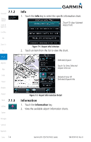
7 Charts Foreword NOTE: The availability of SafeTaxi, ChartView, or FliteCharts in electronic form may not preclude the requirement to carry paper charts aboard the aircraft. See the AFMS for more information. Getting Started Audio & Xpdr Ctrl NOTE: The Chart feature provides a digital representation of a paper chart and provides no vertical or lateral course guidance. Flight Plan and Procedures are separate from Charts, and do provide vertical and lateral course guidance for the loaded route or procedure shown on the Flight Plan page. The term "Chart Unavailable" means that the chart cannot be viewed on the Charts due to either a chart not being published, or an error in the Chart database, but does not preclude its availability or inclusion of the procedure in the Flight Plan or Procedures portion of the system. The absence of a chart for a particular Departure, Arrival, or Approach does not preclude its availability or inclusion in the Flight Plan or Procedures portion of the system. The absence of a particular Departure, Arrival, or Approach under the Flight Plan or Procedures portion of the system does not preclude the ability to view the Chart for that procedure under the Chart feature. Com/Nav FPL Direct-To Proc Charts Wpt Info Map The chart page will default to the nearest airport if no flight plan or destination Traffic airport is present. While you are on the ground, the displayed charts will default to the current airport location regardless of flight plan. The optional ChartView Terrain and FliteCharts provide on-board electronic terminal procedures charts. Electronic charts offer the convenience of rapid access to essential information. Weather Either ChartView or FliteCharts may be configured in the system, but not both. ChartView resembles the paper version of Jeppesen terminal procedures Nearest charts. The charts are displayed in full color with high-resolution. The MFD depiction shows the aircraft position on the moving map in the plan view of Music approach charts and on airport diagrams. Airport Hot Spots are outlined in magenta. The ChartView database subscription is available from Jeppesen, Inc. Utilities Available data includes: • Arrivals (STAR) • Airport Diagrams System • Departure Procedures (DP) • NOTAMs • Approaches Messages An enablement card that is purchased from Garmin is separate from the Jeppesen database and is required to enable ChartView. Symbols Appendix 190-01007-03 Rev. B Garmin GTN 725/750 Pilot's Guide 7-1 Index
-
 1
1 -
2
-
3
-
4
-
5
-
6
-
7
-
8
-
9
-
10
-
11
-
12
-
13
-
14
-
15
-
16
-
17
-
18
-
19
-
20
-
21
-
22
-
23
-
24
-
25
-
26
-
27
-
28
-
29
-
30
-
31
-
32
-
33
-
34
-
35
-
36
-
37
-
38
-
39
-
40
-
41
-
42
-
43
-
44
-
45
-
46
-
47
-
48
-
49
-
50
-
51
-
52
-
53
-
54
-
55
-
56
-
57
-
58
-
59
-
60
-
61
-
62
-
63
-
64
-
65
-
66
-
67
-
68
-
69
-
70
-
71
-
72
-
73
-
74
-
75
-
76
-
77
-
78
-
79
-
80
-
81
-
82
-
83
-
84
-
85
-
86
-
87
-
88
-
89
-
90
-
91
-
92
-
93
-
94
-
95
-
96
-
97
-
98
-
99
-
100
-
101
-
102
-
103
-
104
-
105
-
106
-
107
-
108
-
109
-
110
-
111
-
112
-
113
-
114
-
115
-
116
-
117
-
118
-
119
-
120
-
121
-
122
-
123
-
124
-
125
-
126
-
127
-
128
-
129
-
130
-
131
-
 132
132 -
 133
133 -
 134
134 -
 135
135 -
 136
136 -
 137
137 -
 138
138 -
 139
139 -
 140
140 -
 141
141 -
 142
142 -
143
-
144
-
145
-
146
-
147
-
148
-
149
-
150
-
151
-
152
-
153
-
154
-
155
-
156
-
157
-
158
-
159
-
160
-
161
-
162
-
163
-
164
-
165
-
166
-
167
-
168
-
169
-
170
-
171
-
172
-
173
-
174
-
175
-
176
-
177
-
178
-
179
-
180
-
181
-
182
-
183
-
184
-
185
-
186
-
187
-
188
-
189
-
190
-
191
-
192
-
193
-
194
-
195
-
196
-
197
-
198
-
199
-
200
-
201
-
202
-
203
-
204
-
205
-
206
-
207
-
208
-
209
-
210
-
211
-
212
-
213
-
214
-
215
-
216
-
217
-
218
-
219
-
220
-
221
-
222
-
223
-
224
-
225
-
226
-
227
-
228
-
229
-
230
-
231
-
232
-
233
-
234
-
235
-
236
-
237
-
238
-
239
-
240
-
241
-
242
-
243
-
244
-
245
-
246
-
247
-
248
-
249
-
250
-
251
-
252
-
253
-
254
-
255
-
256
-
257
-
258
-
259
-
260
-
261
-
262
-
263
-
264
-
265
-
266
-
267
-
268
-
269
-
270
-
271
-
272
-
273
-
274
-
275
-
276
-
277
-
278
-
279
-
280
-
281
-
282
-
283
-
284
-
285
-
286
-
287
-
288
-
289
-
290
-
291
-
292
-
293
-
294
-
295
-
296
-
297
-
298
-
299
-
300
-
301
-
302
-
303
-
304
-
305
-
306
-
307
-
308
-
309
-
310
-
311
-
312
-
313
-
314
-
315
-
316
-
317
-
318
-
319
-
320
-
321
-
322
-
323
-
324
-
325
-
326
-
327
-
328
-
329
-
330
-
331
-
332
-
333
-
334
-
335
-
336
-
337
-
338
-
339
-
340
-
341
-
342
-
343
-
344
-
345
-
346
-
347
-
348
-
349
-
350
-
351
-
352
-
353
-
354
-
355
-
356
-
357
-
358
-
359
-
360
-
361
-
362
-
363
-
364
-
365
-
366
-
367
-
368
-
369
-
370
-
371
-
372
-
373
-
374
-
375
-
376
-
377
-
378
-
379
-
380
-
381
-
382
-
383
-
384
-
385
-
386
-
387
-
388
-
389
-
390
-
391
-
392
-
393
-
394
-
395
-
396
-
397
-
398
-
399
-
400
-
401
-
402
-
403
-
404
-
405
-
406
-
407
-
408
-
409
-
410
-
411
-
412
-
413
-
414
-
415
-
416
-
417
-
418
 |
 |