Garmin GTN 750 Pilot's Guide - Page 346
Graph Symbol, Description
 |
View all Garmin GTN 750 manuals
Add to My Manuals
Save this manual to your list of manuals |
Page 346 highlights
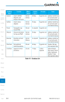
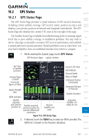
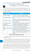
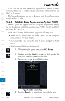
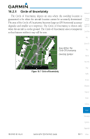
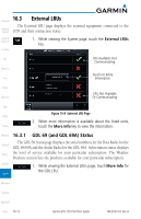
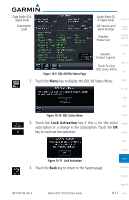
Foreword Getting Started Audio & Xpdr Ctrl Com/Nav 3. Touch the key for the desired SBAS provider. 4. Touch the Back key to return to the System Status page. As the GPS receiver locks onto satellites, a signal strength bar appears for each satellite in view, with the appropriate satellite number (01-32, SBAS satellites will have higher numbers) underneath each bar. The progress of satellite acquisition is shown in three stages: FPL Direct-To Proc Charts Wpt Info Map Traffic Terrain Weather Nearest Graph Symbol Description No signal strength bars The receiver is looking for the satellites indicated. Grey signal strength bars Yellow signal strength bars Cross-hatch cyan signal strength bars Solid cyan signal strength bars Solid green signal strength bars D The receiver has found the satellite(s) and is collecting data. The receiver has collected the necessary data but the satellite is not being used in the position solution as it has been excluded. The receiver has found the satellite(s) but it has been excluded by the FDE program as a faulty satellite. The receiver has collected the necessary data, but is not using the satellite in the position solution. The receiver has collected the necessary data and the satellite is being used in the position solution. The "D" character inside the bars indicates differential corrections (e.g. WAAS) are being used for that satellite. Table 16-2 Signal Strength Bar Graph Description Music The Time and other data may not be displayed until the unit has acquired enough satellites for a fix. Utilities The sky view display at the left of the page shows the satellites currently in view as well as their respective positions. The outer circle of the sky view represents System the horizon (with north at the top of the circle); the inner circle represents 45° above the horizon and the center point shows the position directly overhead. Messages Each satellite has a 30-second data transmission that must be collected Symbols (hollow signal strength bar) before the satellite may be used for navigation (solid signal strength bar). Once the GPS receiver has determined your position, the Appendix GTN unit indicates your position, altitude, track and ground speed. The GPS Index 16-8 Garmin GTN 725/750 Pilot's Guide 190-01007-03 Rev. B
-
 1
1 -
2
-
3
-
4
-
5
-
6
-
7
-
8
-
9
-
10
-
11
-
12
-
13
-
14
-
15
-
16
-
17
-
18
-
19
-
20
-
21
-
22
-
23
-
24
-
25
-
26
-
27
-
28
-
29
-
30
-
31
-
32
-
33
-
34
-
35
-
36
-
37
-
38
-
39
-
40
-
41
-
42
-
43
-
44
-
45
-
46
-
47
-
48
-
49
-
50
-
51
-
52
-
53
-
54
-
55
-
56
-
57
-
58
-
59
-
60
-
61
-
62
-
63
-
64
-
65
-
66
-
67
-
68
-
69
-
70
-
71
-
72
-
73
-
74
-
75
-
76
-
77
-
78
-
79
-
80
-
81
-
82
-
83
-
84
-
85
-
86
-
87
-
88
-
89
-
90
-
91
-
92
-
93
-
94
-
95
-
96
-
97
-
98
-
99
-
100
-
101
-
102
-
103
-
104
-
105
-
106
-
107
-
108
-
109
-
110
-
111
-
112
-
113
-
114
-
115
-
116
-
117
-
118
-
119
-
120
-
121
-
122
-
123
-
124
-
125
-
126
-
127
-
128
-
129
-
130
-
131
-
132
-
133
-
134
-
135
-
136
-
137
-
138
-
139
-
140
-
141
-
142
-
143
-
144
-
145
-
146
-
147
-
148
-
149
-
150
-
151
-
152
-
153
-
154
-
155
-
156
-
157
-
158
-
159
-
160
-
161
-
162
-
163
-
164
-
165
-
166
-
167
-
168
-
169
-
170
-
171
-
172
-
173
-
174
-
175
-
176
-
177
-
178
-
179
-
180
-
181
-
182
-
183
-
184
-
185
-
186
-
187
-
188
-
189
-
190
-
191
-
192
-
193
-
194
-
195
-
196
-
197
-
198
-
199
-
200
-
201
-
202
-
203
-
204
-
205
-
206
-
207
-
208
-
209
-
210
-
211
-
212
-
213
-
214
-
215
-
216
-
217
-
218
-
219
-
220
-
221
-
222
-
223
-
224
-
225
-
226
-
227
-
228
-
229
-
230
-
231
-
232
-
233
-
234
-
235
-
236
-
237
-
238
-
239
-
240
-
241
-
242
-
243
-
244
-
245
-
246
-
247
-
248
-
249
-
250
-
251
-
252
-
253
-
254
-
255
-
256
-
257
-
258
-
259
-
260
-
261
-
262
-
263
-
264
-
265
-
266
-
267
-
268
-
269
-
270
-
271
-
272
-
273
-
274
-
275
-
276
-
277
-
278
-
279
-
280
-
281
-
282
-
283
-
284
-
285
-
286
-
287
-
288
-
289
-
290
-
291
-
292
-
293
-
294
-
295
-
296
-
297
-
298
-
299
-
300
-
301
-
302
-
303
-
304
-
305
-
306
-
307
-
308
-
309
-
310
-
311
-
312
-
313
-
314
-
315
-
316
-
317
-
318
-
319
-
320
-
321
-
322
-
323
-
324
-
325
-
326
-
327
-
328
-
329
-
330
-
331
-
332
-
333
-
334
-
335
-
336
-
337
-
338
-
339
-
340
-
 341
341 -
 342
342 -
 343
343 -
 344
344 -
 345
345 -
 346
346 -
 347
347 -
 348
348 -
 349
349 -
 350
350 -
 351
351 -
352
-
353
-
354
-
355
-
356
-
357
-
358
-
359
-
360
-
361
-
362
-
363
-
364
-
365
-
366
-
367
-
368
-
369
-
370
-
371
-
372
-
373
-
374
-
375
-
376
-
377
-
378
-
379
-
380
-
381
-
382
-
383
-
384
-
385
-
386
-
387
-
388
-
389
-
390
-
391
-
392
-
393
-
394
-
395
-
396
-
397
-
398
-
399
-
400
-
401
-
402
-
403
-
404
-
405
-
406
-
407
-
408
-
409
-
410
-
411
-
412
-
413
-
414
-
415
-
416
-
417
-
418
 |
 |