Pioneer AVIC-D1 Owner's Manual - Page 33
City Map, Display items
 |
UPC - 012562739496
View all Pioneer AVIC-D1 manuals
Add to My Manuals
Save this manual to your list of manuals |
Page 33 highlights
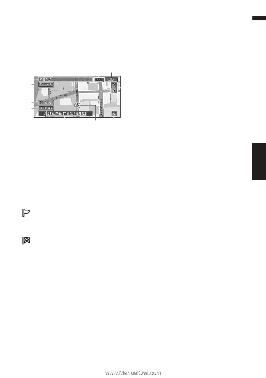
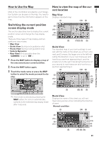
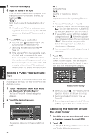
NAVI Chapter 2 Menu and Map Display ❒ If the DVD Map Disc does not contain the data for these items, the information is not available. City Map In certain metropolitan city areas, a more detailed "City Map" is available at the 0.05 mi (50m) map scale or lower. (1) (10) (8) (2) (7) (4) (11) (5) (3) (6) ❒ If the DVD Map Disc does not contain the data for city area, detailed "City Map" is not available. ❒ Except when on a freeway, if you are driving by an area where a City Map is available, at the 0.1 mi (100 m) map scale, a message appears informing you that have entered a city map area. Display items Guidance point* The next guidance point (next turning point, etc.) is shown by a yellow flag. Destination* The checker-flag indicates your destination. (1) Name of the next street to be used* (2) Distance to the guidance point* Touch to access the next information. (3) Current location The current location of your vehicle. The tip of the triangular mark indicates your heading and the display moves automatically as you drive. (4) Distance to the destination (or distance to way point)* If way points are set, the display changes with each touch. When two or more way points are set, the distance to the destination and the distance to the next way point are switched. (5) Name of the street your vehicle is traveling along (or City Name, etc.) (6) Compass The red arrow indicates north. If the scale is less than 25 mi (50 km), touching the map changes the direction it is displayed in (north up/heading up). When the scale of the map is not less than 25 mi (50 km), it is fixed to "north up". Heading up: The map display always shows the vehicle's direction as proceeding toward the top of the screen. North up: The map display always has north at the top of the screen. (7) Zoom in/Zoom out Touch to change the map's scale. ➲ Changing the map's scale ➞ Page 32 (8) Map scale The scale of the map is indicated by distance. Except for on the Vehicle Dynamics Display, the scale of the map is displayed at the top right of the screen. ➲ Changing the map's scale ➞ Page 32 (9) TRAFFIC icon This appears when an XM tuner (GEX-P10XMT, sold separately) is connected, and traffic information is received. (10) Current time (11) Estimated time of arrival (or travel time to your destination)* The display changes with each touch. The estimated time of arrival is automatically calculated from the Average Speed set and the actual average speed. ➲ How to set average speed ➞ Page 64 (12) Tracking mark The tracking mark shows the route your vehicle has traveled by the dots. ➲ Select the tracking setting ➞ Page 65 (13) Map of your surroundings (Side map) Touching on the map briefly shows the shortcut menu, while touching longer changes the map to Scroll mode. ➲ Moving the map to the location you want to see ➞ Page 32 31
-
 1
1 -
2
-
3
-
4
-
5
-
6
-
7
-
8
-
9
-
10
-
11
-
12
-
13
-
14
-
15
-
16
-
17
-
18
-
19
-
20
-
21
-
22
-
23
-
24
-
25
-
26
-
27
-
 28
28 -
 29
29 -
 30
30 -
 31
31 -
 32
32 -
 33
33 -
 34
34 -
 35
35 -
 36
36 -
 37
37 -
 38
38 -
39
-
40
-
41
-
42
-
43
-
44
-
45
-
46
-
47
-
48
-
49
-
50
-
51
-
52
-
53
-
54
-
55
-
56
-
57
-
58
-
59
-
60
-
61
-
62
-
63
-
64
-
65
-
66
-
67
-
68
-
69
-
70
-
71
-
72
-
73
-
74
-
75
-
76
-
77
-
78
-
79
-
80
-
81
-
82
-
83
-
84
-
85
-
86
-
87
-
88
-
89
-
90
-
91
-
92
-
93
-
94
-
95
-
96
-
97
-
98
-
99
-
100
-
101
-
102
-
103
-
104
-
105
-
106
-
107
-
108
-
109
-
110
-
111
-
112
-
113
-
114
-
115
-
116
-
117
-
118
-
119
-
120
-
121
-
122
-
123
-
124
-
125
-
126
-
127
-
128
-
129
-
130
-
131
-
132
-
133
 |
 |