Pioneer AVIC-D1 Owner's Manual - Page 34
Changing the scale of the map, Moving the map to the location, you want to see
 |
UPC - 012562739496
View all Pioneer AVIC-D1 manuals
Add to My Manuals
Save this manual to your list of manuals |
Page 34 highlights
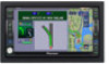
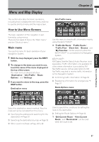
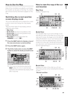
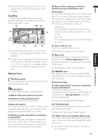
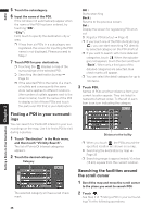
NAVI Menu and Map Display Chapter 2 (14) Distance to an intersection* Displayed on the enlarged intersection map. The green bar gets shorter as your vehicle approaches an intersection. (15) Next direction of travel* When you approach an intersection, it appears green. The screen displays the distance to the next guidance point, and the next guidance point after that. (16) Area to Avoid ➲ About detour area ➞ Page 42 (17) Direction line The direction towards the location set in (4) is indicated with a straight line. (18) Lane information* Lane information is displayed the first time voice guidance is used. When the guidance screen is displayed near an interchange or exit, the lane information disappears. (19) Freeway signs* These show the road number and give directional information. (20) Freeway exit information* Displays the freeway exit. ❒ Information with the mark (*) appears only when the route is set. ❒ Depending on the conditions and settings, some items may not be displayed. ❒ The icon of a registered location and the traffic information icons are displayed when the map scale is 10 miles (20 km) or lower. ❒ POI icons and the line for traffic congestion and traffic flow are displayed when the map scale is 0.75 mile (1 km) or lower. ❒ The Direct scale key may not appear depending on the map display mode. Moving the map to the location you want to see If you touch the display briefly, the shortcut menu appears. Touching anywhere on the map for at least 2 seconds changes the map to Scroll mode and the map begins scrolling in the direction you touched. The scrolling stops when you release your finger from the screen. At this time, the scroll cursor appears at the center of the screen. Also a line connecting between the current location and scroll cursor appears. Pressing the MAP button returns you to the map of your surroundings. ❒ Touch the area close to the center of the screen to scroll slowly; touch near the sides of the screen to scroll through quickly. (3) (1) (2) Changing the scale of the map Touching the "Zoom in/Zoom out" key displayed on the upper right of the screen displays the scale gauge and "Direct scale" key. Directly touching the "Direct scale" key changes the map to the selected scale. Touching or above the scale gauge allows you to specify the scale in greater detail within a range of 25 yards - 1000 miles (25 meters - 2000 kilometers). Direct scale key (5) (4) (1) Scroll location The position of scroll cursor shows the location selected on the current map. ❒ When the scale is 0.25 mi (200 m) or lower, the road appears light blue in the vicinity of the scroll cursor. (2) Direction line The direction towards the scroll cursor is indicated with a straight line. (3) Distance from the current location 32
-
 1
1 -
2
-
3
-
4
-
5
-
6
-
7
-
8
-
9
-
10
-
11
-
12
-
13
-
14
-
15
-
16
-
17
-
18
-
19
-
20
-
21
-
22
-
23
-
24
-
25
-
26
-
27
-
28
-
 29
29 -
 30
30 -
 31
31 -
 32
32 -
 33
33 -
 34
34 -
 35
35 -
 36
36 -
 37
37 -
 38
38 -
 39
39 -
40
-
41
-
42
-
43
-
44
-
45
-
46
-
47
-
48
-
49
-
50
-
51
-
52
-
53
-
54
-
55
-
56
-
57
-
58
-
59
-
60
-
61
-
62
-
63
-
64
-
65
-
66
-
67
-
68
-
69
-
70
-
71
-
72
-
73
-
74
-
75
-
76
-
77
-
78
-
79
-
80
-
81
-
82
-
83
-
84
-
85
-
86
-
87
-
88
-
89
-
90
-
91
-
92
-
93
-
94
-
95
-
96
-
97
-
98
-
99
-
100
-
101
-
102
-
103
-
104
-
105
-
106
-
107
-
108
-
109
-
110
-
111
-
112
-
113
-
114
-
115
-
116
-
117
-
118
-
119
-
120
-
121
-
122
-
123
-
124
-
125
-
126
-
127
-
128
-
129
-
130
-
131
-
132
-
133
 |
 |