Pioneer AVIC-D1 Owner's Manual - Page 53
Confirming traffic information, on the map
 |
UPC - 012562739496
View all Pioneer AVIC-D1 manuals
Add to My Manuals
Save this manual to your list of manuals |
Page 53 highlights
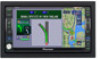
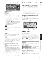
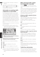
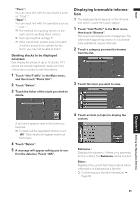
NAVI (1) (2) (4) (5) (3) (1) Street or place (2) Direction (3) Incident (4) Distance to the location (5) The incident numbers currently displayed and the total number of incidents ❒ The incidents that have already been read will be displayed in white. Unread incidents will be in yellow. ❒ Touching the allows you to check the place on a map. (Traffic information without positional information cannot be checked on a map.) : You can sort the traffic information in alphabetical order. : You can sort the traffic information according to the incident. : You can sort the traffic information by distance from your current position. : When new traffic information is received, current information is changed, or old information has been removed, the list is updated to reflect the new situation. 3 Select an incident you want to view in detail. The details of the selected incident are displayed. • Touching an incident you want to see allows you to view the detailed information of the incident. If the information cannot be displayed on one screen, touch or to view the remaining information. 4 Touch "Back" to return to the list with traffic information. A list with traffic information appears again. Checking traffic information on the route 1 Touch "Info/Traffic" in the Main menu, and then touch "Traffic On Route". The currently set traffic information on the route appears on the screen. ❒ The method for checking the content dis- played on the screen is the same for "Checking all traffic information". ➲ Checking all traffic information ➞ Page 50 Confirming traffic information on the map The traffic-related information displayed on the map is as follows. (3) (2) (1) (or ): (1) TRAFFIC icon When a route has been calculated, touch to check whether there is any traffic congestion information on your route. When no route has been calculated, touch to display the traffic list. ❒ When is displayed, the data is being loaded from the DVD Map Disc. (2) A line to indicate the length of the traffic congestion (displayed only when the scale on the map is 0.75 mile (1km) or lower). Traffic congestion: Orange with white outline: stop and go traffic Red with white outline: stopped traffic Black with white outline: closed/blocked roads (3) Icon for traffic information (appears only when the scale on the map is 10 mi (20 km) or lower) ❒ Traffic-related icons are not displayed on city maps. Chapter 4 Editing the Navigation Utilities 51
-
 1
1 -
2
-
3
-
4
-
5
-
6
-
7
-
8
-
9
-
10
-
11
-
12
-
13
-
14
-
15
-
16
-
17
-
18
-
19
-
20
-
21
-
22
-
23
-
24
-
25
-
26
-
27
-
28
-
29
-
30
-
31
-
32
-
33
-
34
-
35
-
36
-
37
-
38
-
39
-
40
-
41
-
42
-
43
-
44
-
45
-
46
-
47
-
 48
48 -
 49
49 -
 50
50 -
 51
51 -
 52
52 -
 53
53 -
 54
54 -
 55
55 -
 56
56 -
 57
57 -
 58
58 -
59
-
60
-
61
-
62
-
63
-
64
-
65
-
66
-
67
-
68
-
69
-
70
-
71
-
72
-
73
-
74
-
75
-
76
-
77
-
78
-
79
-
80
-
81
-
82
-
83
-
84
-
85
-
86
-
87
-
88
-
89
-
90
-
91
-
92
-
93
-
94
-
95
-
96
-
97
-
98
-
99
-
100
-
101
-
102
-
103
-
104
-
105
-
106
-
107
-
108
-
109
-
110
-
111
-
112
-
113
-
114
-
115
-
116
-
117
-
118
-
119
-
120
-
121
-
122
-
123
-
124
-
125
-
126
-
127
-
128
-
129
-
130
-
131
-
132
-
133
 |
 |
