Garmin GPS 152 Owner's Manual
Garmin GPS 152 - Marine Receiver Manual
 |
UPC - 753759028145
View all Garmin GPS 152 manuals
Add to My Manuals
Save this manual to your list of manuals |
Garmin GPS 152 manual content summary:
- Garmin GPS 152 | Owner's Manual - Page 1
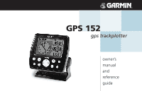
GPS 152 gps trackplotter owner's ZOOM manual and reference guide - Garmin GPS 152 | Owner's Manual - Page 2
provided herein, no part of this manual may be reproduced, copied, transmitted, disseminated, downloaded or stored in any storage medium, for any purpose without the express prior written consent of GARMIN. GARMIN hereby grants permission to download a single copy of this manual and of any revision - Garmin GPS 152 | Owner's Manual - Page 3
the easiest-to-use fixed-mount GPS trackplotters available! The GARMIN GPS 152 utilizes the proven performance of GARMIN GPS to create an unsurpassed marine navigation system. To get the most out of your new GARMIN unit, take the time to read this owner's manual and learn the operating procedures for - Garmin GPS 152 | Owner's Manual - Page 4
different from that to which the receiver is connected. • Consult the dealer or and experienced radio/TV technician for help. The GPS 152 does not contain any user-serviceable parts. Repairs should only be made by an authorized GARMIN service center. Unauthorized repairs or modifications could result - Garmin GPS 152 | Owner's Manual - Page 5
the GARMIN GPS 152 is a precision electronic NAVigation AID (NAVAID), any NAVAID can be misused or misinterpreted and, therefore, become unsafe. CAUTION: Use the GPS 152 at your own risk. To reduce the risk of unsafe operation, carefully review and understand all aspects of this Owner's Manual-and - Garmin GPS 152 | Owner's Manual - Page 6
cover of this manual for shipping instructions and an RMA tracking number. The unit should be securely packed with the tracking number clearly written on the outside of the package. The unit should be sent, freight charges prepaid, to any GARMIN warranty service station. A copy of the original sales - Garmin GPS 152 | Owner's Manual - Page 7
GARMIN GPS 152 is a powerful device that can give you the navigation information you need. Precision Performance • High-contrast, four-level gray, FSTN display with adjustable backlighting • 12-channel parallel receiver to 1 Megabytes of data using GARMIN's MapSource™ PC products • Coordinates: Lat - Garmin GPS 152 | Owner's Manual - Page 8
your GARMIN dealer immediately. Standard Package: • GPS 152 Unit • GA 29 External Antenna and 30-ft. cable* • Power/Data Cable • Mount with 2 knobs • Owner's Manual • Quick Reference Card * Not included with package containing the internal antenna. Optional Accessories: • US A/C and PC Adapter - Garmin GPS 152 | Owner's Manual - Page 9
Usage 1 Selecting Options 2 Entering Data 3 Initializing the Receiver 4 Power On 6 Contrast 6 Backlighting 7 Simulator Mode 7 Description of Main Pages 8 Map Page Cursor 9 Marking Waypoints 10 Going to a Destination 11 Simulated Tour 12 Reviewing and Creating Waypoints 13 Compass and - Garmin GPS 152 | Owner's Manual - Page 10
new GPS 152. viii TO DO THIS: SEE PAGE(S): Access the Main Menu 16, 53 Adjust screen contrast and/or backlighting 6-7 Change the displayed time (zone 56 Change units of measure (statute, nautical, metric 58-59 Configure the Map page display 21-26 Create and use a route 44-51 Enter data - Garmin GPS 152 | Owner's Manual - Page 11
Menu. Getting Started Keypad Usage POWER/BACKLIGHT/CONTRAST Key The POWER/BACKLIGHT/CONTRAST key turns ON/OFF the unit and display illumination. PAGE Key Power Key ARROW KEYPAD The ARROW KEYPAD is used to select (highlight) menu options and enter data. It also controls cursor movement on the Map - Garmin GPS 152 | Owner's Manual - Page 12
Started tour before using your unit for actual navigation. You can select and activate options and enter data to customize the GPS 152 to fit your requirements. page 3), you will observe functions such as 'Delete', 'Map' and 'OK'. To activate the function, highlight the desired button and press the ENTER - Garmin GPS 152 | Owner's Manual - Page 13
of symbols. The coordinates can be changed. The waypoint can be renamed. A depth can be entered. Option buttons can be activated. Getting Started Entering Data Pressing UP or DOWN on the ARROW KEYPAD changes the highlighted number or letter. Pressing LEFT or RIGHT on the ARROW KEYPAD moves the - Garmin GPS 152 | Owner's Manual - Page 14
sure the GPS 152 unit and antenna have been correctly installed on your vessel according to the instructions in Appendix G. The antenna needs to be in a location with a clear and unobstructed view of the sky to receive satellite signals. To turn the GPS 152 on: 1. Press and hold the POWER key until - Garmin GPS 152 | Owner's Manual - Page 15
• Solid signal strength bars- the receiver has collected the necessary data and the satellite(s) are ready for use. Once the receiver has collected information from at least three satellites, the top of the screen will display either "2D or 3D Navigation", and the GPS 152 is ready for use. Getting - Garmin GPS 152 | Owner's Manual - Page 16
that the receiver has been properly installed and initialized, and you have not changed any of the unit's default settings. If you have changed any settings (position formats, units of measure, etc.), the descriptions and pictures in the tour may not match your configuration. To turn the GPS 152 on - Garmin GPS 152 | Owner's Manual - Page 17
cycle through off, the user-defined, and maximum backlight levels by repeatedly pressing the POWER key. Each page and the Main Menu of the GPS 152's system may also feature brighter or down for dimmer backlighting. When the unit is in Simulator mode, an 'S' will appear in the lower left corner of - Garmin GPS 152 | Owner's Manual - Page 18
Active Route Page Numbers Page QUIT To continue the tour, move to the Map Page. To scroll to the next page in sequence: 1. Press the PAGE key. The GPS 152's Map Page combines trackplotting with a user-selectable display of navigation data. It will also be the page you use most to create and edit - Garmin GPS 152 | Owner's Manual - Page 19
position calculated by the receiver, which should be the spot where you've initialized the unit). This will also give you an opportunity to see how the GPS 152's keypad and ENTER/MARK key are used for data entry and changing the waypoint name and symbol. Getting Started Map Cursor Current position - Garmin GPS 152 | Owner's Manual - Page 20
not save the waypoint. The waypoint is now stored in memory. Note that waypoints may also be created graphically with the Map Page cursor or by manually entering position coordinates. These techniques are described in the reference section of the manual and/or on the GPS 152 Quick Reference Guide. - Garmin GPS 152 | Owner's Manual - Page 21
GPS is all about marking positions as waypoints and navigating to them using the receiver's steering guidance and map displays. You've already seen how to use the ENTER/MARK key to store our present position, so it's time to move on to the fun part . To change the GPS 152 position in simulator mode - Garmin GPS 152 | Owner's Manual - Page 22
MARK to confirm. 3. The Select Route page will appear, with the 'GPS TOUR' route highlighted. 4. Press ENTER/MARK then highlight 'Activate' and press ENTER/ The Map Page should now display the first three waypoints chained together in a simple route, with your boat at the first route waypoint. A data - Garmin GPS 152 | Owner's Manual - Page 23
to your route, you can pan ahead of your vessel with the cursor to review map items and create on-screen waypoints. Try moving the cursor to highlight the ' you'll notice that the waypoint symbol and name will become highlighted. The data field at the top of the page will display the waypoint name, - Garmin GPS 152 | Owner's Manual - Page 24
Compass Ring Pointer Arrow Current Waypoint Data Fields Desired Course Zoom Scale 14 Present Position Now that we're navigating to an actual destination, let's move on to the GPS 152 navigation pages by pressing the PAGE key. The GPS 152 features two different navigation pages: Compass - Garmin GPS 152 | Owner's Manual - Page 25
each waypoint name along with useful data for each point. As you navigate the route, the information will automatically update to indicate the next point along Numbers Page. The default page will display four user-selectable data fields showing the speed, pointer, distance to the next waypoint, and - Garmin GPS 152 | Owner's Manual - Page 26
ve seen, the primary pages provide map and navigation information. The tour's last page is the Main Menu page, which allows access to the GPS 152's waypoint, route and planning functions, various operational and navigation setup features, and celestial and tidal data. The Main Menu is available from - Garmin GPS 152 | Owner's Manual - Page 27
the GARMIN GPS 152. Your new GPS is a powerful tool with many advanced features not covered in the Getting Started tour. For detailed instructions on using these features or performing a specific task, please refer to the Quick Reference Guide or the appropriate reference section of this manual. To - Garmin GPS 152 | Owner's Manual - Page 28
of Interest or other MapSource data is loaded into the unit, the tides, cities and marine navaids will be deleted from the system. Check the GARMIN web site (www.garmin.com) for updates to reinstall the original factory-loaded data. 18 Map Page The GPS 152's Map Page provides a display of plotting - Garmin GPS 152 | Owner's Manual - Page 29
your present position to the cursor will be displayed in the data window, along with the cursor's position coordinates. When you screen waypoints and map items, allowing you to review details about a selected position directly from the map display. To select an on-screen waypoint or map item with the - Garmin GPS 152 | Owner's Manual - Page 30
key will capture the current location, not the cursor's location). 3. The 'New Map Waypoint' window will appear. With 'OK' highlighted, press ENTER/MARK to confi , with the current scale displayed at the bottom right of the data window. To select a map scale: 1. Press the OUT key to zoom out and the - Garmin GPS 152 | Owner's Manual - Page 31
layout of various types of useful data. Each data field may be configured to display any one of 28 data options. The data window layout may also be changed to display additional data fields and change the actual size of the data displayed. The GPS 152's Map Page options menu provides access to - Garmin GPS 152 | Owner's Manual - Page 32
options are available for display in data fields on the Map, Highway, Compass, and Numbers pages: • BEARING - Compass direction from your position to destination • COURSE - Course over ground • DEPTH - Depth below transducer (if receiving proper sonar NMEA data from other device) • DIST TO DEST - Garmin GPS 152 | Owner's Manual - Page 33
destination • WATER SPEED - Speed through the water (if receiving proper sonar NMEA data from other device) • WATER TEMP - Water temperature (if receiving proper sonar NMEA data from other device) To change a data field: 1. Highlight the 'Change Data Fields' option and press ENTER/MARK. 2. Move the - Garmin GPS 152 | Owner's Manual - Page 34
option uses a 'file tab' feature, making it easier to organize the various settings for ease of use. To change a map setup feature: 1. From the Map Page menu, highlight the 'Configure Map' option and press ENTER/MARK. 2. Move LEFT or RIGHT on the ARROW KEYPAD to highlight the desired file tab, then - Garmin GPS 152 | Owner's Manual - Page 35
. Source Tab Data - On/Off: turns the loaded map data on or off. Points Tab - Waypoints, Active Route, Marine Navaids, and data will only show up to certain zoom scales. Other Tab Accuracy Circle - On/Off: toggles the circle "On" or "Off." The circle represents the approximate accuracy of the unit - Garmin GPS 152 | Owner's Manual - Page 36
Highlight 'Restore Defaults' (highlight 'Restore All Map Defaults' if you want all tabs restored) and press ENTER/MARK. Compass Page Whenever a NAV/MOB, Follow Track (TracBack) or Follow Route has been activated, the GPS 152's Compass Page will guide you to your destination with digital readouts and - Garmin GPS 152 | Owner's Manual - Page 37
the desired option and press ENTER/MARK. For detailed instructions on changing the data fields and data text size of the Compass Page, see pages 22-23. Highway Page Whenever a NAV/MOB, TracBack or route has been activated, the GPS 152's Highway Page will provide digital and graphic steering guidance - Garmin GPS 152 | Owner's Manual - Page 38
field may be configured to display any one of 28 data options (Change Data Fields). The data field layout may also be altered to change the actual text size of the data displayed (Big/Small Numbers). The GPS 152's Highway Page features a menu options page that provides access to functions and features - Garmin GPS 152 | Owner's Manual - Page 39
Active Route Page Whenever you activate a route in the GPS 152 system, the Active Route page will show each waypoint of the active route, along with various, user-selectable types of data. For additional details on the Active Route Page, see page 52. Numbers Page The Numbers Page allows quick and - Garmin GPS 152 | Owner's Manual - Page 40
- allows you to define a new waypoint position from the map display using the ARROW KEYPAD. • Text Entry - allows you to enter a new waypoint's position coordinates manually (from a chart, etc.). ENTER/MARK Key The GARMIN GPS 152's ENTER/MARK key lets you quickly capture your present position in - Garmin GPS 152 | Owner's Manual - Page 41
are receiving valid sonar NMEA input (page 83) , the depth field will automatically fill in. Otherwise, you must manually map position or map feature to create a new waypoint. When you move the cursor over a map item, you will see a highlighted description of that item. The GPS 152 will use the map - Garmin GPS 152 | Owner's Manual - Page 42
accept the waypoint with the default name and symbol based on the map feature, highlight 'OK' and press ENTER/MARK. To change the will appear, with the next available waypoint number and the receiver's last known position as the default name and position. data, highlight 'OK' and press ENTER/MARK. - Garmin GPS 152 | Owner's Manual - Page 43
the right on the ARROW KEYPAD. Press ENTER/MARK when done. Reference Editing Waypoints Symbol Name Coordinates Depth Waypoint Review Page Select 'OK' to exit/save changes and return to the Map Page. Waypoint Edit Page Select 'Next' to exit/save changes and return to the next waypoint in the - Garmin GPS 152 | Owner's Manual - Page 44
and bearing of the map pointer (the location you're moving the waypoint to). If you wish to stop the move process, press QUIT. 3. With the pointer at the desired position, press ENTER/MARK. To return to the Waypoint Review/ Waypoint Edit page, press QUIT. Waypoint Lists The GPS 152's Main Menu Page - Garmin GPS 152 | Owner's Manual - Page 45
From the By Name list, you may review, edit, rename or delete individual waypoints, or delete all user waypoints. The total number of stored and the unit. It is advisable to back up important waypoints to a computer using an optional PC cable and interface software or write them down manually. - Garmin GPS 152 | Owner's Manual - Page 46
the Waypoint tab shows the ten nearest waypoints that are within 200 nautical miles of your present position. The nearest waypoints are continuously updated to your present position, and provide quick access to the closest points of safety in emergency situations. The bearing and distance from your - Garmin GPS 152 | Owner's Manual - Page 47
will automatically move to the next waypoint in the list. You can review details of each waypoint in any waypoint list by pressing ENTER/MARK repeatedly 'Proximity Overlaps Another Proximity Waypoint' message will appear each time the unit is turned on. If you enter an alarm circle overlap, you - Garmin GPS 152 | Owner's Manual - Page 48
or 'Nearest' waypoint lists. The Waypoint Review page will appear for the selected waypoint. With To select a waypoint from the map, press MENU. With 'Select From Map' highlighted, press ENTER/MARK. KEYPAD to enter a distance value (to 99.99 units). Press ENTER/MARK when finished. To turn proximity - Garmin GPS 152 | Owner's Manual - Page 49
to a Destination Using the NAV/MOB key, the GPS 152 provides four ways to navigate to a destination: Go With 'Go To' highlighted on the Waypoint Review page, press ENTER/MARK to confirm. To select a waypoint from the map, press MENU. With 'Select From Map' highlighted, press ENTER/MARK. Use the zoom - Garmin GPS 152 | Owner's Manual - Page 50
not be stored in the waypoint list. See page 32 for creating waypoints using map features. If you are selecting a new map point (non-map item) as the 'Go To' destination, the GPS 152 will automatically create or move a waypoint named 'MAP' at the cursor position. To activate an existing waypoint or - Garmin GPS 152 | Owner's Manual - Page 51
to retrace your path using the track log automatically stored in the receiver's memory, which will eliminate the need to store waypoints along the name the track and specify whether or not to show the track on the Map and Highway pages. Press the QUIT key to exit. Reference TracBack Navigation - Garmin GPS 152 | Owner's Manual - Page 52
box to display track on the Map and Highway pages. Total Distance ENTER/MARK. Once a TracBack has been activated, the GPS 152 takes the track log currently stored in memory and divides to 'resolution' for best performance). • If the receiver is turned off or satellite coverage is lost during your - Garmin GPS 152 | Owner's Manual - Page 53
MOB The GPS 152's Man OverBoard function (MOB) lets you simultaneously mark and set a course to ' waypoint with a diver down symbol will be created and the unit will be on an active navigation to that point. Use any of the Navigation Pages to guide you back to the MOB point. The MOB waypoint will be - Garmin GPS 152 | Owner's Manual - Page 54
user-defined route. The GARMIN GPS 152 system lets you create and store up to 20 reversible routes (numbered 1-20), with up to 30 waypoints each. Routes can be created and modified in two ways. One is to 'Edit as Text' from the Route Review page. ) Note: To use map items as route points, you will need - Garmin GPS 152 | Owner's Manual - Page 55
each new waypoint to the route, the data window at the top of the map display will show the waypoint/map item name, bearing and distance from your finished press MENU, highlight either 'Edit as Text' to return to the Route Review page, or 'Stop Editing Route' (or press QUIT) to return to the Route - Garmin GPS 152 | Owner's Manual - Page 56
name will automatically appear. Route List Menu 46 Route List Page The GPS 152 Route List page displays all the routes currently stored in memory, along with /MARK. (If you highlight a route from the Route List or Route Review page and press NAV/MOB, the window will automatically display, 'Follow < - Garmin GPS 152 | Owner's Manual - Page 57
Time, Sunrise and Sunset (at point location) and Time To (point). Totals for distance and the data fields are displayed at the bottom of the page. To view the trip planning data fields: 1. From the Route Review page, use the ARROW KEYPAD to highlight a waypoint from the list. 2. Press RIGHT or LEFT on - Garmin GPS 152 | Owner's Manual - Page 58
more information on editing waypoints). Use the ARROW KEYPAD to choose 'Delete' (permanently delete the waypoint from the unit), 'Map' (view the waypoint on the map), or 'Next' (exit the Waypoint Review page and highlight the next point on the route list). Press ENTER/MARK when finished. If the point - Garmin GPS 152 | Owner's Manual - Page 59
. The Waypoint Review page will appear if the route point is a waypoint, and the Information page will appear if the route point is a map item. with and press ENTER/MARK. 4. If you are not inserting an existing waypoint or map feature, press ENTER/MARK to confirm the new waypoint. 5. Repeat steps - Garmin GPS 152 | Owner's Manual - Page 60
waypoint (shown), map item, or a blank spot on the map to create a new route point. 50 The GPS 152's Edit on Map mode also allows you map and press ENTER/MARK. Remove Waypoint - Allows you to remove a point (waypoint or map item) from a route. This option is available from both the Route Review - Garmin GPS 152 | Owner's Manual - Page 61
information for your vehicle (operator's manual, performance specifications, etc.) and make note of the desired units of measure (gallons, liters, etc.). Delete Route - Deletes route and any map item points within route. To delete a route: 1. From the Route Review page press MENU. 2. Highlight - Garmin GPS 152 | Owner's Manual - Page 62
activated a route in the GPS 152 system, the Active Route page shows each point (waypoint or map item) of the active route, with the point name, distance and choice of selectable data fields for each point from your present position (just like the Route Review page). The current destination point - Garmin GPS 152 | Owner's Manual - Page 63
interface management, and setup menus in an easy to use "tab" format. The Main Menu page is available from any page in the GPS 152's system, and is accessed through the MENU key. See pages 2-3 for additional instructions changing settings and entering data to'. • Map - Sets up Map Page features, - Garmin GPS 152 | Owner's Manual - Page 64
units of measure. • Com (Communication)- Has interface settings for use with a PC or second device. • Alrm (Alarm)- Sets up alarms for anchor drag, arrival, off course, and clock. • Celes (Celestial) - Shows sun/moon time cycles and positions. • GPS track log data for future activation, map display - Garmin GPS 152 | Owner's Manual - Page 65
true course before recording a track point. Distance - Records track based on a user-defined distance between points. • Value - Defines the distance or time used ENTER/MARK. Reference Main Menu: Track Tab Use the 'Show Map' option to display a saved track. The track name will automatically appear when - Garmin GPS 152 | Owner's Manual - Page 66
Speed, Stopped Time, Moving Time, Total Time, and Odometer. To reset data in the Trip tab: 1. Press MENU, then highlight 'Reset Trip', ' pressing MENU: • Enable All Pages - Selects all pages. • Basic Trackplotter - Selects Map page only. • Nav Tools Only - Selects Compass, Highway, and Active - Garmin GPS 152 | Owner's Manual - Page 67
for additional instructions. The following options are available by pressing MENU on the System tab: • Restore Garmin Setup - Restores ALL settings to GARMIN's original setup values for the entire unit. • Software Version - Displays the unit's software and Unit ID. For registering the GPS 152, use - Garmin GPS 152 | Owner's Manual - Page 68
will affect how navigation information is displayed on the GPS 152. When in doubt, seek assistance. If you are using a map or chart in conjunction with your GPS, make sure the settings under the 'Units' tab of the GPS 152 match that of the map or chart. This information should be displayed somewhere - Garmin GPS 152 | Owner's Manual - Page 69
Temperature*- lets you select the desired units of measure for temperature in Fahrenheit (°F) or Celsius (°C). * You must be receiving proper sonar NMEA data from another device for this data to display. See pages 83-84. Reference Main Menu: Units Tab You may manually enter a magnetic variation. 59 - Garmin GPS 152 | Owner's Manual - Page 70
used when connecting your GPS 152 to external NMEA devices, a DGPS beacon receiver, a personal computer, another Garmin GPS 152, etc. Six format settings are available for serial data transfer: • Garmin Data Transfer - The proprietary format used to upload/download MapSource data, exchange waypoint - Garmin GPS 152 | Owner's Manual - Page 71
is selected, additional fields are provided to control a GARMIN differential beacon receiver directly from your GPS 152. You may have the unit automatically scan for the DGPS beacon signal or you can enter the beacon frequency and bit rate on the unit and the information will be used to tune the - Garmin GPS 152 | Owner's Manual - Page 72
maintenance. For DGPS transmitter problems or to find the most updated list of frequencies and or local) you're using for your system. The unit must be on for the clock alarm to work. • turn the alarms on and off. * You must be receiving sonar NMEA data for this function to work (see pages 83-84). - Garmin GPS 152 | Owner's Manual - Page 73
sun and moon. The moon phase will display the current visible portion of the moon as a light color. You may display this data for your current position, a position from the map, or a waypoint location. You may also select a different date and/or time, and change the sky view orientation to 'North Up - Garmin GPS 152 | Owner's Manual - Page 74
Dark signal strength bars - The receiver has collected the necessary data and is ready for use. Sky View GPS tab Signal Strength Bars Center dot - 90° 90° above the horizon Inner ring- 45° above the horizon As soon as the GPS 152 has collected the necessary data from the best satellites in view - Garmin GPS 152 | Owner's Manual - Page 75
the receiver status. To learn more about the WAAS system, its satellite positions and current state of development, visit the FAA web site (http://gps.faa.gov). Since WAAS requires CPU resources of the GPS 152 to search for and track the satellites, you may disable the WAAS feature to improve unit - Garmin GPS 152 | Owner's Manual - Page 76
. DGPS • No Signal - DGPS receiver attached, but not transmitting RTCM data to GPS. Status • Tuning - Receiver is tuning manual frequency. • Scanning - DGPS receiver is scanning for available frequency. • Rcving - Unit is receiving DGPS corrections. • Chk Wiring - DGPS is enabled in Com menu - Garmin GPS 152 | Owner's Manual - Page 77
on the Map Page to initially help the receiver acquire more quickly. See pages 4-5 for instructions on initialization. • Set 2D Altitude - Allows you to manually enter the altitude when in 2D Navigation or Simulator mode only. Any altitude entered will be automatically calculated when the GPS is in - Garmin GPS 152 | Owner's Manual - Page 78
You can select from a list of nearest stations or from the map. 68 Tide Tab- shows a graphical chart which displays tide station /above 'LCL' and 'STA' indicate the maximum/minimum levels, respectively. The four data fields below the chart, indicate event times and levels at which the tide changes - Garmin GPS 152 | Owner's Manual - Page 79
the 'Select From Map' option and select a location closer to a tide station. To select a tide station from the map: 1. From unit, the tides, cities and marine navaids will be deleted from the system. Check the GARMIN web site (www.garmin.com) for updates to reinstall the original factory-loaded data - Garmin GPS 152 | Owner's Manual - Page 80
system covers the entire United States and the U.S. Coastal Confluence Zone. From the perspective of a mariner, the unit is placed in the LORAN TD format mode, it simulates the operation of a LORAN receiver. information will reflect those changes. Since the GPS unit does not rely on the LORAN signal for - Garmin GPS 152 | Owner's Manual - Page 81
When done, press the QUIT key to return to the Map Page. If the active GRI Chain, secondary stations or the TD coordinates accordingly. Remember that the GPS is not relying on the LORAN signal using it for navigation. Because of this, the unit can navigate to a TD coordinate anywhere in the world. - Garmin GPS 152 | Owner's Manual - Page 82
Appendix B Time Offsets + A simple way to determine your local time offset is how many hours you are behind or ahead of UTC (also called 'Greenwich' or 'zulu' time). Example: EST (Eastern Standard Time) is 5 hours behind UTC, so your offset would be -5. Adding one hour for daylight savings would - Garmin GPS 152 | Owner's Manual - Page 83
Check antenna connections or try moving to a location with a clear view of the sky. Memory (RAM) Failed Unit Needs Repair- Internal problem with unit. Contact your dealer or GARMIN Customer Service (page i) to have the unit serviced. Memory (ROM) Failed Unit Needs Repair- Internal problem with unit - Garmin GPS 152 | Owner's Manual - Page 84
will not fit into memory. The oldest track log points were deleted to make space for the most recent data. Transfer Complete- The unit has finished uploading/downloading information to the connected device. Waypoint Already Exists: - You have entered a waypoint name that already exists - Garmin GPS 152 | Owner's Manual - Page 85
- Bangladesh, India, Nepal Indian- Thailand, Vietnam Indonesia 1974-Indonesia Ireland 1965- Ireland ISTS 073 ASTRO '69- Diego Garcia Johnston Island Appendix D Map Datums ) The 'User' datum is based on a WGS-84-Local datum and is an advanced feature for unlisted or custom datums. Check your local - Garmin GPS 152 | Owner's Manual - Page 86
Map NAD27 Mexico NAD27 San Sal NAD83 Naparima BWI Nhrwn Masirah Nhrwn Saudi A Nhrwn United A Obsrvtorio '66 Old Egyptian Old Hawaiian Oman Ord Srvy GB Pico De Ast '68 Viti Levu 1916 Wake-Eniwetok WGS 72 WGS 84 Zanderij User Qornoq- South Greenland Reunion- Mascarene Island Rome 1940- Sardinia Isl. - Garmin GPS 152 | Owner's Manual - Page 87
waypoint (in sequence) in the route. Max Speed- The maximum second-by-second speed recorded since last reset. Moving Average Speed- Average speed while the unit is moving. Moving Trip Timer- Total time the unit has been moving. Appendix E Navigation Terms 77 - Garmin GPS 152 | Owner's Manual - Page 88
tally of distance travelled since last reset. Also see 'Odometer'. Total Average Speed- Average speed of unit for both moving and stopped speeds since last timer reset. Total Trip Timer- Total time the unit has been in operation since last reset of the trip timers. Turn- The angle difference between - Garmin GPS 152 | Owner's Manual - Page 89
Update Rate: 1/second, continuous GPS Accuracy: Position*: - Garmin GPS 152 | Owner's Manual - Page 90
GPS 152 with the built-in internal bail mount antenna, you may skip this section and proceed to the next page. For units purchased with the external GA 29 antenna, follow the instructions below. To complete the installation, you'll need the appropriate fasteners and a 1" x 14-thread marine antenna - Garmin GPS 152 | Owner's Manual - Page 91
. 4. Insert the GPS 152 into the mounting bracket. The bracket is designed for a tight fit to provide additional support when swiveling the unit. 5. Screw the two mounting knobs through the bracket and into the display case. 6. Connect the power/data and antenna cables (external antenna only) to the - Garmin GPS 152 | Owner's Manual - Page 92
the unit's flange and bracket lobe (figure 1). 5. Tighten the knobs and connect the power/data and antenna cables. Note: if the panel is too thick to allow use of the supplied knobs, two M6 screws may be used to secure the bracket. The International version of the GPS 152, with external antenna, can - Garmin GPS 152 | Owner's Manual - Page 93
Connecting the Power/Data The power/data cable connects the GPS 152 to a 10-40 volt DC system and provides interface capabilities for connecting external devices. The color code in the diagram below indicates the appropriate harness connections. The replacement fuse is an AGC/3AG - 1.5 Amp fuse. - Garmin GPS 152 | Owner's Manual - Page 94
Advanced NMEA Setup Page 84 NMEA Interface If you are going to interface the GPS 152 with another piece of equipment (such as a radar or autopilot), the unit needs to be set to output NMEA data. The NMEA data can be customized to shorten the update time from the unit. If too many NMEA sentences are - Garmin GPS 152 | Owner's Manual - Page 95
A Accessories vi Accuracy Map 24-26 Contrast Setting 6 Course Line 25 Cursor Movement 9, 18-19 Customer Service i D Data Entry 3 Data Fields 22-23 Data Transfer 60 Date/Time 56 Daylight Savings Time 56 Deep Water Alarm 62 Depth Units 59 DGPS Interfacing 60-62, 66 Differential Receiver - Garmin GPS 152 | Owner's Manual - Page 96
56 Position Format 58 Power Off 17 Power On 4, 6 Power/Backlight/Contrast Key 1 Preface i Proximity Waypoints 37-38 Q QUIT Key 1 R Receiver Status 64-67 Re-evaluate Active Route 52 Registration i Restore GARMIN Setup 57 Reviewing Waypoints 13, 19, 33-38 Reviewing Map Items 19 Route List - Garmin GPS 152 | Owner's Manual - Page 97
55 Recording 54 Trip and Fuel Planning 47, 51 Trip Timers 56 U Units of Measure 58-59 User Map Datum 75-76 W WAAS Capability 64-65 Warnings iii Warranty iv Appendix I -37 Proximity 37-38 Reviewing 13, 19, 33-38 Symbols 10, 13, 33-36 Wiring Installation 86 Z Zooming 9, 12, 15, 20, 27 87 - Garmin GPS 152 | Owner's Manual - Page 98
the latest free software updates throughout the life of your GARMIN products, visit the GARMIN web site at www.garmin.com. © Copyright 2001-2002 GARMIN Ltd. or its subsidiaries GARMIN International, Inc. 1200 East 151st Street, Olathe, Kansas 66062, U.S.A. GARMIN (Europe) Ltd. Unit 5, The Quadrangle
-
 1
1 -
 2
2 -
 3
3 -
 4
4 -
 5
5 -
 6
6 -
 7
7 -
8
-
9
-
10
-
11
-
12
-
13
-
14
-
15
-
16
-
17
-
18
-
19
-
20
-
21
-
22
-
23
-
24
-
25
-
26
-
27
-
28
-
29
-
30
-
31
-
32
-
33
-
34
-
35
-
36
-
37
-
38
-
39
-
40
-
41
-
42
-
43
-
44
-
45
-
46
-
47
-
48
-
49
-
50
-
51
-
52
-
53
-
54
-
55
-
56
-
57
-
58
-
59
-
60
-
61
-
62
-
63
-
64
-
65
-
66
-
67
-
68
-
69
-
70
-
71
-
72
-
73
-
74
-
75
-
76
-
77
-
78
-
79
-
80
-
81
-
82
-
83
-
84
-
85
-
86
-
87
-
88
-
89
-
90
-
91
-
92
-
93
-
94
-
95
-
96
-
97
-
98
 |
 |

ZOOM
owner’s
manual
and
reference
guide
gps trackplotter
GPS 152