Garmin GPS 152 Owner's Manual - Page 32
Map Options - transducer
 |
UPC - 753759028145
View all Garmin GPS 152 manuals
Add to My Manuals
Save this manual to your list of manuals |
Page 32 highlights
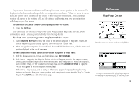
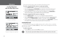
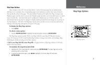
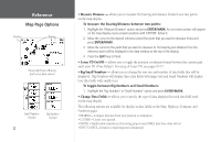
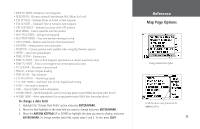
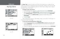
Reference Map Page Options Distance Bearing Measuring Distance/Bearing (Full Screen Mode shown) Small Numbers (4 fields) Big Numbers (3 fields) 22 • Measure Distance - allows you to measure the bearing and distance between any two points on the map display. To measure the Bearing/Distance between two points: 1. Highlight the 'Measure Distance' option and press ENTER/MARK. An on-screen pointer will appear on the map display at your present position with 'ENT REF' below it. 2. Move the cursor to the desired reference point (the point that you want to measure from) and press ENTER/MARK. 3. Move the cursor to the point that you want to measure to. The bearing and distance from the reference point will be displayed in the data window at the top of the display. 4. Press the QUIT key to finish. • Loran TD On/Off - allows you to toggle the position coordinate format between the current grid and Loran TD (Time Delays). For setup of Loran TD, see pages 70-71. • Big/Small Numbers - allows you to change the text size and number of data fields that will be displayed. Big Numbers will display three data fields with larger text and Small Numbers will display four data fields with smaller text. To toggle between Big Numbers and Small Numbers: 1. Highlight the 'Big Numbers' or 'Small Numbers' option and press ENTER/MARK. • Change Data Fields - allows you to specify the type of data displayed in each data field used on the map display. The following options are available for display in data fields on the Map, Highway, Compass, and Numbers pages: • BEARING - Compass direction from your position to destination • COURSE - Course over ground • DEPTH - Depth below transducer (if receiving proper sonar NMEA data from other device) • DIST TO DEST - Distance to final waypoint (destination)
-
 1
1 -
2
-
3
-
4
-
5
-
6
-
7
-
8
-
9
-
10
-
11
-
12
-
13
-
14
-
15
-
16
-
17
-
18
-
19
-
20
-
21
-
22
-
23
-
24
-
25
-
26
-
 27
27 -
 28
28 -
 29
29 -
 30
30 -
 31
31 -
 32
32 -
 33
33 -
 34
34 -
 35
35 -
 36
36 -
 37
37 -
38
-
39
-
40
-
41
-
42
-
43
-
44
-
45
-
46
-
47
-
48
-
49
-
50
-
51
-
52
-
53
-
54
-
55
-
56
-
57
-
58
-
59
-
60
-
61
-
62
-
63
-
64
-
65
-
66
-
67
-
68
-
69
-
70
-
71
-
72
-
73
-
74
-
75
-
76
-
77
-
78
-
79
-
80
-
81
-
82
-
83
-
84
-
85
-
86
-
87
-
88
-
89
-
90
-
91
-
92
-
93
-
94
-
95
-
96
-
97
-
98
 |
 |
