Garmin GPS 152 Owner's Manual - Page 19
Map Cursor - gps receiver reviews
 |
UPC - 753759028145
View all Garmin GPS 152 manuals
Add to My Manuals
Save this manual to your list of manuals |
Page 19 highlights
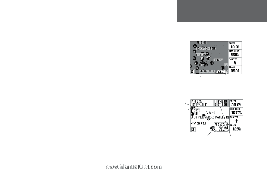
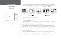
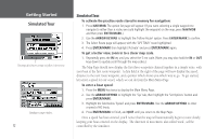
The Map Page Cursor Working from the Map Page is a simple process that centers around the use of the cursor. Controlled by the ARROW KEYPAD, the cursor is an important tool that can be used to pan to other map locations, mark and edit waypoints and routes, and review position data of on-screen map items and waypoints. To get a feel for using the Map Page and using the cursor, try the following exercise: 1. Use the IN/OUT keys to set the map scale to the 50 nm setting. Your boat should be near the center of the map, at the receiver's last known position (If your boat isn't where it should be, make sure that you have initialized the receiver and acquired a position as described on pages 4-5). 2. Use the ARROW KEYPAD to move the cursor. Notice how another data field, 'Map Pointer', appears at the top of the page. This field shows the bearing and distance from your boat to the cursor, along with the latitude/longitude of the cursor. 3. Press the QUIT key to remove the cursor and re-center your boat on the map display. As you become more familiar with the cursor, you'll see that the map display actively scrolls or "pans," letting you explore areas around the world and create waypoints and routes. Wherever you move the cursor, you'll always be just one QUIT key press away from returning the map to your present position. Now that you've seen how the GPS tab and Map Page can be used to monitor satellite acquisition and your present location, let's take a minute to learn how to mark and store your present position as a waypoint (Since you're in simulator mode, the present position displayed will be the last position calculated by the receiver, which should be the spot where you've initialized the unit). This will also give you an opportunity to see how the GPS 152's keypad and ENTER/MARK key are used for data entry and changing the waypoint name and symbol. Getting Started Map Cursor Current position Map Scale Distance Bearing Map Cursor Cursor Coordinates 9
-
 1
1 -
2
-
3
-
4
-
5
-
6
-
7
-
8
-
9
-
10
-
11
-
12
-
13
-
 14
14 -
 15
15 -
 16
16 -
 17
17 -
 18
18 -
 19
19 -
 20
20 -
 21
21 -
 22
22 -
 23
23 -
 24
24 -
25
-
26
-
27
-
28
-
29
-
30
-
31
-
32
-
33
-
34
-
35
-
36
-
37
-
38
-
39
-
40
-
41
-
42
-
43
-
44
-
45
-
46
-
47
-
48
-
49
-
50
-
51
-
52
-
53
-
54
-
55
-
56
-
57
-
58
-
59
-
60
-
61
-
62
-
63
-
64
-
65
-
66
-
67
-
68
-
69
-
70
-
71
-
72
-
73
-
74
-
75
-
76
-
77
-
78
-
79
-
80
-
81
-
82
-
83
-
84
-
85
-
86
-
87
-
88
-
89
-
90
-
91
-
92
-
93
-
94
-
95
-
96
-
97
-
98
 |
 |