Uniden BCD325P2 Owners Manual - Page 65
Location-based Scanning, Non Radio Location-based Gps Features, Connecting Your Scanner
 |
View all Uniden BCD325P2 manuals
Add to My Manuals
Save this manual to your list of manuals |
Page 65 highlights
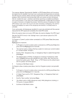
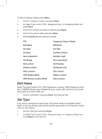
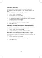
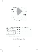
USING THE BCD325P2 WITH A GPS LOCATION-BASED SCANNING You can connect the scanner to an optional GPS device (BC-GPSK using the BCUTGC cable) and set the scanner to automatically lock and unlock trunked sites and channel groups based on the location information and range settings you program for those sites/groups. This frees you from having to manually enable and disable sites/groups as you change location. The BCD325P2 uses the data, supplied by an (optional) attached GPS unit, that lets the radio automatically unlock and lockout sites/groups based on latitude and longitude. It uses the (programmed) center of the site/group, and the (programmed) range - the radius of a circle around the latitude and longitude up to 125 miles from that center. A good application of this feature would be to set the longitude and latitude for each multi-site system transmitter as usually you can receive at least a handful in any given location. You can find the physical location of antennas using the databases available at Radio Reference or the FCC's Antenna Structure Registration site. Both sites list the latitude, longitude, and height of the antenna, and both sites can map the exact location for you. Radio Reference is more user-friendly, so it's easier to find what you're looking for. NON RADIO LOCATION-BASED GPS FEATURES When connected to a GPS, you can program specific location information which will trigger an alert from the scanner. The scanner becomes an extension of the GPS device. Even if you don't use the scanner to scan, you can enhance you GPS unit with information the scanner provides. The scanner also allows you to program audio and/or visual alerts for a: Point of Interest (POI): Stores location and range. If you approach the set location, the radio sounds an alert up to 4 miles/km from the center. Dangerous Road/Dangerous Crossing: Stores location, direction of travel, and speed. If you are traveling at a speed greater than that specified, in the direction specified, and if you are within range of the set location, the scanner sounds an alert at 1, .5, and .1 miles/km from the point. These range distances are also automatic and fixed. You can also temporarily lockout (cancel) any combination of these alerts. CONNECTING YOUR SCANNER Connect BC-GPS (receiver) and BC-UTGC (cable) to USB port, following the instructions provided with them. 65
-
 1
1 -
2
-
3
-
4
-
5
-
6
-
7
-
8
-
9
-
10
-
11
-
12
-
13
-
14
-
15
-
16
-
17
-
18
-
19
-
20
-
21
-
22
-
23
-
24
-
25
-
26
-
27
-
28
-
29
-
30
-
31
-
32
-
33
-
34
-
35
-
36
-
37
-
38
-
39
-
40
-
41
-
42
-
43
-
44
-
45
-
46
-
47
-
48
-
49
-
50
-
51
-
52
-
53
-
54
-
55
-
56
-
57
-
58
-
59
-
 60
60 -
 61
61 -
 62
62 -
 63
63 -
 64
64 -
 65
65 -
 66
66 -
 67
67 -
 68
68 -
 69
69 -
 70
70 -
71
-
72
-
73
-
74
-
75
-
76
-
77
-
78
-
79
-
80
-
81
-
82
-
83
-
84
-
85
-
86
-
87
-
88
-
89
-
90
-
91
-
92
-
93
-
94
-
95
-
96
-
97
-
98
-
99
-
100
-
101
-
102
-
103
-
104
-
105
-
106
-
107
-
108
-
109
-
110
-
111
-
112
-
113
-
114
-
115
-
116
-
117
-
118
-
119
-
120
-
121
-
122
-
123
-
124
-
125
-
126
-
127
-
128
-
129
-
130
-
131
-
132
 |
 |