Garmin GPSMAP 740/740s Owner's Manual - Page 52
Units of Measure, About Chart Overlay Numbers, Selecting a Standardized System of Measurement
 |
View all Garmin GPSMAP 740/740s manuals
Add to My Manuals
Save this manual to your list of manuals |
Page 52 highlights
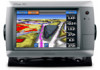
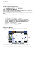
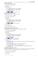
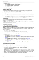
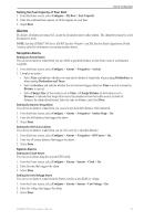
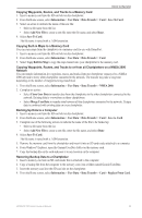
Device Configuration Units of Measure You can set the units of measure the chartplotter shows, using a standardized system of measurements or creating a customized system of measurements. Selecting a Standardized System of Measurement 1. From the Home screen, select Configure > Units > System Units. 2. Select Statute (mh, ft, ºF), Metric (kh, m, ºC), or Nautical (kt, ft, ºF). Creating a Customized System of Measurement You must be receiving NMEA Sonar depth data or using an "S" series chartplotter (such as a GPSMAP 720s) with a built-in sounder to view depth and temperature information. You can select individual units of measure to create a customized system of measurement for your chartplotter display. 1. From the Home screen, select Configure > Units > System Units > Custom. 2. Complete an action: • Select Depth, and select Feet, Fathoms, or Meters. • Select Temperature, and select Fahrenheit (ºF) or Celsius (ºC). • Select Distance, and select Miles, Kilometers, Nautical (nm, ft) or Nautical (nm, m). • Select Speed > Vessel Speed, and select Miles Per Hour, Kilometers Per Hour, or Knots. • Select Speed > Wind Speed, and select Miles Per Hour, Meters Per Sec, or Knots. • Select Elevation, and select Feet or Meters. • Select Volume, and select Litres, US Gallons, or UK Gallons. • Select Pressure > Gauge Pressure, and select kPa or psi. • Select Pressure > Atmospheric Pressure, and select Millibars or Inches of Mercury. About Chart Overlay Numbers Overlay numbers with data fields ➊ can appear on specific charts, 3D charts, radar views (page 66), and combination screens (page 22). The data overlay for each chart or 3D chart view can be configured separately. ➊ ➊ Navigation Chart with Data Overlay Several data overlays are available. You can select the data fields to be shown within each data overlay. When overlay numbers are displayed on the chart, the navigation inset is shown during navigation. The compass tape can be shown or hidden in each overlay. 48 GPSMAP 700 Series Owner's Manual
-
 1
1 -
2
-
3
-
4
-
5
-
6
-
7
-
8
-
9
-
10
-
11
-
12
-
13
-
14
-
15
-
16
-
17
-
18
-
19
-
20
-
21
-
22
-
23
-
24
-
25
-
26
-
27
-
28
-
29
-
30
-
31
-
32
-
33
-
34
-
35
-
36
-
37
-
38
-
39
-
40
-
41
-
42
-
43
-
44
-
45
-
46
-
 47
47 -
 48
48 -
 49
49 -
 50
50 -
 51
51 -
 52
52 -
 53
53 -
 54
54 -
 55
55 -
 56
56 -
 57
57 -
58
-
59
-
60
-
61
-
62
-
63
-
64
-
65
-
66
-
67
-
68
-
69
-
70
-
71
-
72
-
73
-
74
-
75
-
76
-
77
-
78
-
79
-
80
-
81
-
82
-
83
-
84
-
85
-
86
-
87
-
88
-
89
-
90
-
91
-
92
-
93
-
94
-
95
-
96
-
97
-
98
-
99
-
100
 |
 |