Garmin GPSMAP 6012 Owner's Manual - Page 38
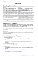
Navigation, Basic Navigation Questions, Navigation with a Chartplotter
 |
View all Garmin GPSMAP 6012 manuals
Add to My Manuals
Save this manual to your list of manuals |
Page 38 highlights
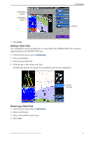
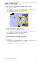
Navigation Navigation Basic Navigation Questions Question Answer How do I make the chartplotter point me in the direction in which I want to go (bearing)? Navigate using Go To. See "Setting and Following a Direct Course Using Go To" (page 32). How do I make the device guide me along a straight Build a single-leg route and navigate it using Route To line (minimizing cross track) to a location using the (page 35). shortest distance from the present location? How do I make the device guide me to a location while avoiding obstacles? Build a multi-leg route and navigate it using Route To. See "Creating and Navigating a Route from Your Present Location" (page 34). How do I make the device steer my automatic pilot? Navigate using Route To (page 35). Can the device create a path for me? If you have a BlueChart g2 Vision data card, navigate using Auto Guidance. See "Setting and Following a Course Using Auto Guidance" (page 32). How do I change the Auto Guidance settings for my See "Auto Guidance Line Configurations" (page 59). boat? Navigation with a Chartplotter To navigate using a GPSMAP 6000 or 7000 series chartplotter, you must first choose a destination, set a course or create a route, and follow the course or route. You can follow the course or the route on the Navigation chart, the Fishing chart, Perspective 3D, or Mariner's Eye 3D. Note: The Fishing chart and Mariner's Eye 3D are available with a preprogrammed BlueChart g2 Vision data card. Destinations You can select destinations using various charts and 3D chart views, or you can select a destination using the Where To? feature. Selecting a Destination Using the Navigation Chart 1. From the Home screen, select Charts > Navigation Chart. 2. Select where you want to go: • For the GPSMAP 6000 series, use the Rocker to select the destination using the cursor ( ). • For the GPSMAP 7000 series, touch the navigation chart to select the destination using the cursor ( ). Selecting a Destination Using Where To? 1. From the Home screen, select Where To?. 2. Complete an action: • Select Waypoints to view a list of preloaded locations and locations you marked previously (page 34). • Select Routes to view a list of routes you saved previously (page 35). • Select Tracks to view a list of recorded tracks (page 39). 32 GPSMAP® 6000/7000 Series Owner's Manual
-
 1
1 -
2
-
3
-
4
-
5
-
6
-
7
-
8
-
9
-
10
-
11
-
12
-
13
-
14
-
15
-
16
-
17
-
18
-
19
-
20
-
21
-
22
-
23
-
24
-
25
-
26
-
27
-
28
-
29
-
30
-
31
-
32
-
 33
33 -
 34
34 -
 35
35 -
 36
36 -
 37
37 -
 38
38 -
 39
39 -
 40
40 -
 41
41 -
 42
42 -
 43
43 -
44
-
45
-
46
-
47
-
48
-
49
-
50
-
51
-
52
-
53
-
54
-
55
-
56
-
57
-
58
-
59
-
60
-
61
-
62
-
63
-
64
-
65
-
66
-
67
-
68
-
69
-
70
-
71
-
72
-
73
-
74
-
75
-
76
-
77
-
78
-
79
-
80
-
81
-
82
-
83
-
84
-
85
-
86
-
87
-
88
-
89
-
90
-
91
-
92
-
93
-
94
-
95
-
96
-
97
-
98
-
99
-
100
-
101
-
102
-
103
-
104
-
105
-
106
-
107
-
108
-
109
-
110
-
111
-
112
-
113
-
114
-
115
-
116
-
117
-
118
-
119
-
120
-
121
-
122
-
123
-
124
-
125
-
126
-
127
-
128
-
129
-
130
-
131
-
132
 |
 |