Pioneer AVIC-Z110BT Owner's Manual - Page 41
Operating the map screen, How to use the map
 |
UPC - 012562956404
View all Pioneer AVIC-Z110BT manuals
Add to My Manuals
Save this manual to your list of manuals |
Page 41 highlights
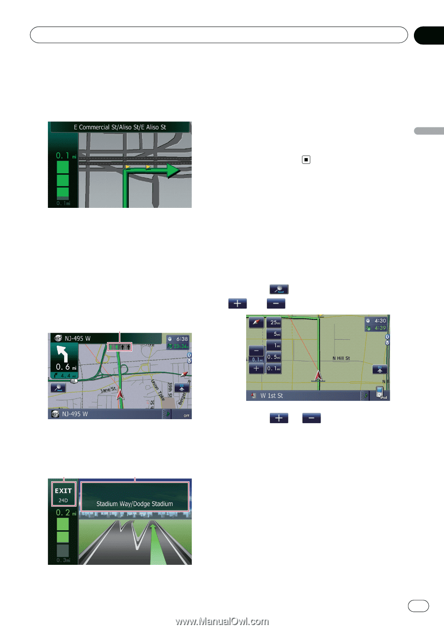
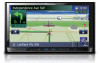
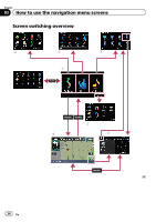
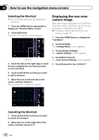
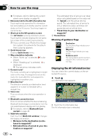
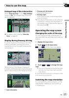
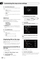
How to use the map Chapter 04 Enlarged map of the intersection When "Close Up View" in the "Map Settings" screen is "On", an enlarged map of the intersection appears. 2 Freeway exit information Displays the freeway exit. 3 Freeway signs These show the road number and give directional information. p If the data for these items is not contained in the built-in memory, the information is not available even if there are the signs on the actual road. How to use the map = For details, refer to Setting "Close Up View" on page 44. Display during freeway driving In certain locations of the freeway, lane information is available, indicating the recommended lane to be in to easily maneuver the next guidance. 1 Operating the map screen Changing the scale of the map You can change the map scale between 25 yard and 1 000 miles (25 meters and 2 000 kilometers). 1 Display the map screen. 2 Touch and on the map screen. with the map scale appear. While driving on the freeway, freeway exit numbers and freeway signs may be displayed when in the vicinity of interchanges and exits. 2 3 3 Touch or to change the map scale. p If you do not operate the function for a few seconds, the initial map screen automati- cally returns. # Touch the direct scale key to change the map to the selected scale directly. Switching the map orientation You can switch the vehicle's direction on the map between "Heading up" and "North up". ! Heading up: 1 Lane information En 41
-
 1
1 -
2
-
3
-
4
-
5
-
6
-
7
-
8
-
9
-
10
-
11
-
12
-
13
-
14
-
15
-
16
-
17
-
18
-
19
-
20
-
21
-
22
-
23
-
24
-
25
-
26
-
27
-
28
-
29
-
30
-
31
-
32
-
33
-
34
-
35
-
 36
36 -
 37
37 -
 38
38 -
 39
39 -
 40
40 -
 41
41 -
 42
42 -
 43
43 -
 44
44 -
 45
45 -
 46
46 -
47
-
48
-
49
-
50
-
51
-
52
-
53
-
54
-
55
-
56
-
57
-
58
-
59
-
60
-
61
-
62
-
63
-
64
-
65
-
66
-
67
-
68
-
69
-
70
-
71
-
72
-
73
-
74
-
75
-
76
-
77
-
78
-
79
-
80
-
81
-
82
-
83
-
84
-
85
-
86
-
87
-
88
-
89
-
90
-
91
-
92
-
93
-
94
-
95
-
96
-
97
-
98
-
99
-
100
-
101
-
102
-
103
-
104
-
105
-
106
-
107
-
108
-
109
-
110
-
111
-
112
-
113
-
114
-
115
-
116
-
117
-
118
-
119
-
120
-
121
-
122
-
123
-
124
-
125
-
126
-
127
-
128
-
129
-
130
-
131
-
132
-
133
-
134
-
135
-
136
-
137
-
138
-
139
-
140
-
141
-
142
-
143
-
144
-
145
-
146
-
147
-
148
-
149
-
150
-
151
-
152
-
153
-
154
-
155
-
156
-
157
-
158
-
159
-
160
-
161
-
162
-
163
-
164
-
165
-
166
-
167
-
168
-
169
-
170
-
171
-
172
-
173
-
174
-
175
-
176
-
177
-
178
-
179
-
180
-
181
-
182
-
183
-
184
-
185
-
186
-
187
-
188
-
189
-
190
-
191
-
192
-
193
-
194
-
195
-
196
-
197
-
198
-
199
-
200
-
201
-
202
-
203
-
204
-
205
-
206
-
207
-
208
-
209
-
210
-
211
-
212
-
213
-
214
-
215
-
216
 |
 |