Pioneer AVIC-5000NEX Owner's Manual - Page 28
Configuring the driving, display, How to use the map
 |
View all Pioneer AVIC-5000NEX manuals
Add to My Manuals
Save this manual to your list of manuals |
Page 28 highlights
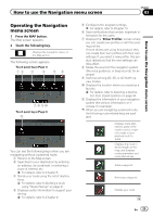
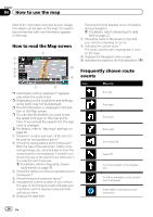
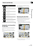
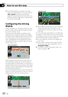
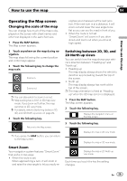
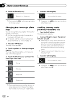
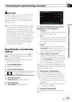
Chapter 04 How to use the map p The estimated time of arrival is an ideal value calculated based on the value set for "Max. Speed" and the actual driving speed. The estimated time of arrival is only a reference value, and does not guarantee arrival at that time. Junction view Configuring the driving display When navigating on multilane roads, you will need to make sure to take the proper lane for the recommended route. If there is lane information available in the map data, the navigation system will display the lanes and corresponding directions of travel at the bottom of the map using small arrows. Highlighted arrows represent the lane and direction that you need to take for the recommended route. Lane information p If the data for these items is not contained in the map data, the information is not available even if there are signs on the actual road. An icon showing a gas station or a restaurant will appear on the map during you are driving on freeways. Touch the icon to open the details of the next few exits or service stations. p You can add any of them as a waypoint to your route. p If you want to display other types of POIs for the exits, you can change the icons in "Navigation Map". = For details, refer to "Navigation Map" settings on page 51. Signs display at the top of the map. Sign colors and design styles are similar to those of the actual signs in place above or along the indicated roads. These signs display select destinations and the road number of the road that the relevant lane leads to. If you are approaching a complex intersection and the needed information exists, the map is replaced with a 3D view of the junction. Signposts 28 En
-
 1
1 -
2
-
3
-
4
-
5
-
6
-
7
-
8
-
9
-
10
-
11
-
12
-
13
-
14
-
15
-
16
-
17
-
18
-
19
-
20
-
21
-
22
-
 23
23 -
 24
24 -
 25
25 -
 26
26 -
 27
27 -
 28
28 -
 29
29 -
 30
30 -
 31
31 -
 32
32 -
 33
33 -
34
-
35
-
36
-
37
-
38
-
39
-
40
-
41
-
42
-
43
-
44
-
45
-
46
-
47
-
48
-
49
-
50
-
51
-
52
-
53
-
54
-
55
-
56
-
57
-
58
-
59
-
60
-
61
-
62
-
63
-
64
-
65
-
66
-
67
-
68
-
69
-
70
-
71
-
72
-
73
-
74
-
75
-
76
-
77
-
78
-
79
-
80
-
81
-
82
-
83
-
84
-
85
-
86
-
87
-
88
-
89
-
90
-
91
-
92
-
93
-
94
-
95
-
96
-
97
-
98
-
99
-
100
-
101
-
102
-
103
-
104
-
105
-
106
-
107
-
108
-
109
-
110
-
111
-
112
-
113
-
114
-
115
-
116
-
117
-
118
-
119
-
120
-
121
-
122
-
123
-
124
-
125
-
126
-
127
-
128
-
129
-
130
-
131
-
132
-
133
-
134
-
135
-
136
-
137
-
138
-
139
-
140
-
141
-
142
-
143
-
144
-
145
-
146
-
147
-
148
-
149
-
150
-
151
-
152
-
153
-
154
-
155
-
156
-
157
-
158
-
159
-
160
-
161
-
162
-
163
-
164
-
165
-
166
-
167
-
168
-
169
-
170
-
171
-
172
-
173
-
174
-
175
-
176
-
177
-
178
-
179
-
180
-
181
-
182
-
183
-
184
-
185
-
186
-
187
-
188
-
189
-
190
-
191
-
192
-
193
-
194
-
195
-
196
-
197
-
198
-
199
-
200
-
201
-
202
-
203
-
204
-
205
-
206
-
207
-
208
-
209
-
210
-
211
-
212
-
213
-
214
-
215
-
216
-
217
-
218
-
219
-
220
-
221
-
222
-
223
-
224
-
225
-
226
-
227
-
228
 |
 |
