Pioneer AVIC-X850BT Operation Manual - Page 30
How to use the map
 |
View all Pioneer AVIC-X850BT manuals
Add to My Manuals
Save this manual to your list of manuals |
Page 30 highlights
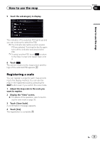
Chapter 03 How to use the map p When there is no data of current position, no information is displayed. ! The AV source currently selected p Depending on the source currently chosen, an image is displayed. 6 Phone key Displays the "Phone" screen. = For details, refer to Displaying the phone menu on page 61. 7 Direction line* The direction towards your destination (next waypoint, or the position of a cursor) is indicated with a straight line. 8 Current route* The route currently set is highlighted in color on the map. If a waypoint is set on the route, the route after the next waypoint is highlighted in another color. 9 Next direction of travel* As you get closer to the guidance point, the color of the item changes to green. a Distance to the guidance point* Shows the distance to the next guidance point. b Second maneuver arrow* Shows the turning direction after the next guidance point and the distance to it. c Number and name of the street to be used (or next guidance point)* Displays the number and name of the upcoming street. If you touch , the street name is scrolled and hidden letters appear. d Estimated time of arrival at your destination or waypoint* The estimated time of arrival is an ideal value calculated based on the value set for Minor Ordinary Road, Major Ordinary Road or Freeway, and the actual driving speed. The estimated time of arrival is only a reference value, and does not guarantee arrival at that time. = For details, refer to Changing the virtual speed of the vehicle on page 143. e Distance to the destination (or distance to waypoint)* Meaning of guidance flags Icon Meaning Destination The checkered flag indicates your destination. Waypoint The red flags indicate your waypoints. Guidance point The next guidance point (next turning point, etc.) is shown by an orange flag. Enlarged map of the intersection When "Close Up View" in the "Guide" screen is "On", an enlarged map of the intersection appears. = For details, refer to Setting the auto-zoom display on page 143. p When the enlarged map of traffic circle appears, the exit numbers are displayed on each exit. The voice guidance is announced from the entrance to the exit. 30 En
-
 1
1 -
2
-
3
-
4
-
5
-
6
-
7
-
8
-
9
-
10
-
11
-
12
-
13
-
14
-
15
-
16
-
17
-
18
-
19
-
20
-
21
-
22
-
23
-
24
-
 25
25 -
 26
26 -
 27
27 -
 28
28 -
 29
29 -
 30
30 -
 31
31 -
 32
32 -
 33
33 -
 34
34 -
 35
35 -
36
-
37
-
38
-
39
-
40
-
41
-
42
-
43
-
44
-
45
-
46
-
47
-
48
-
49
-
50
-
51
-
52
-
53
-
54
-
55
-
56
-
57
-
58
-
59
-
60
-
61
-
62
-
63
-
64
-
65
-
66
-
67
-
68
-
69
-
70
-
71
-
72
-
73
-
74
-
75
-
76
-
77
-
78
-
79
-
80
-
81
-
82
-
83
-
84
-
85
-
86
-
87
-
88
-
89
-
90
-
91
-
92
-
93
-
94
-
95
-
96
-
97
-
98
-
99
-
100
-
101
-
102
-
103
-
104
-
105
-
106
-
107
-
108
-
109
-
110
-
111
-
112
-
113
-
114
-
115
-
116
-
117
-
118
-
119
-
120
-
121
-
122
-
123
-
124
-
125
-
126
-
127
-
128
-
129
-
130
-
131
-
132
-
133
-
134
-
135
-
136
-
137
-
138
-
139
-
140
-
141
-
142
-
143
-
144
-
145
-
146
-
147
-
148
-
149
-
150
-
151
-
152
-
153
-
154
-
155
-
156
-
157
-
158
-
159
-
160
-
161
-
162
-
163
-
164
-
165
-
166
-
167
-
168
-
169
-
170
-
171
-
172
-
173
-
174
-
175
-
176
-
177
-
178
-
179
-
180
-
181
-
182
-
183
-
184
-
185
-
186
-
187
-
188
-
189
-
190
-
191
-
192
-
193
-
194
-
195
-
196
-
197
-
198
-
199
-
200
-
201
-
202
-
203
-
204
 |
 |