Canon XF705 Instruction Manual - Page 112
Recording GPS Information (Geotagging), Connecting the GPS Receiver, Connecting the GP, Receiver
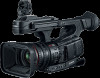 |
View all Canon XF705 manuals
Add to My Manuals
Save this manual to your list of manuals |
Page 112 highlights
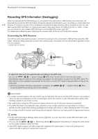
Recording GPS Information (Geotagging) Recording GPS Information (Geotagging) 112 When the optional GP-E2 GPS Receiver is connected to the camcorder's USB terminal, the camcorder will automatically record the GPS information (longitude, latitude and altitude) to every recording you make (clips and photos). For photos only, the UTC (coordinated universal time) date and time will be recorded as well. You can later use this GPS information to organize and search clips using Canon XF Utility (A 153). In mode, you can check if a clip contains GPS information on the [Clip Info] screen (A 140). For details about attaching and configuring the receiver, refer to the GP-E2's instruction manual. Connecting the GPS Receiver Turn off the camcorder and the receiver. Connect the receiver to the camcorder's USB terminal using the USB cable*. While recording, place the receiver in the carrying case* and attach it to the camcorder's grip belt or carry it on your person. * Supplied with the receiver. USB terminal To adjust the date and time automatically according to the GPS data You can set > [B ! System Setup] > [GPS Auto Time] to [On], to have the camcorder automatically adjust its date and time settings according to the information received from the GPS signal. The date and time will be updated automatically the first time a correct GPS signal is acquired after turning on the camcorder. • While the automatic date/time adjustment is activated, the Zone] and [Date/Time] settings will not be available. > [B ! System Setup] > [Time IMPORTANT • In certain countries/regions, the use of GPS may be restricted. Be sure to use the GPS receiver in accordance with local laws and regulations of the country/region where the receiver is used. Be particularly careful when traveling outside of your home country. • Be careful about using the GPS receiver in places where the use of electronic devices is restricted. • The GPS information recorded with clips and photos may contain data that can lead others to locate or identify you. Be careful when sharing geotagged recordings with others or when uploading them to the Web. • Do not leave the GPS receiver near strong electromagnetic fields such as near powerful magnets and motors. NOTES • On the [GPS Information Display] status screen (A 205), you can check the current GPS information and satellite signal strength. • You can use the > [¢ % Monitoring Setup] > [Displayed Units] setting to change the units shown on the screen between meters and feet. • Initial GPS signal reception will take longer after replacing the battery pack or when first turning on the camcorder after a period of having been turned off.
-
 1
1 -
2
-
3
-
4
-
5
-
6
-
7
-
8
-
9
-
10
-
11
-
12
-
13
-
14
-
15
-
16
-
17
-
18
-
19
-
20
-
21
-
22
-
23
-
24
-
25
-
26
-
27
-
28
-
29
-
30
-
31
-
32
-
33
-
34
-
35
-
36
-
37
-
38
-
39
-
40
-
41
-
42
-
43
-
44
-
45
-
46
-
47
-
48
-
49
-
50
-
51
-
52
-
53
-
54
-
55
-
56
-
57
-
58
-
59
-
60
-
61
-
62
-
63
-
64
-
65
-
66
-
67
-
68
-
69
-
70
-
71
-
72
-
73
-
74
-
75
-
76
-
77
-
78
-
79
-
80
-
81
-
82
-
83
-
84
-
85
-
86
-
87
-
88
-
89
-
90
-
91
-
92
-
93
-
94
-
95
-
96
-
97
-
98
-
99
-
100
-
101
-
102
-
103
-
104
-
105
-
106
-
 107
107 -
 108
108 -
 109
109 -
 110
110 -
 111
111 -
 112
112 -
 113
113 -
 114
114 -
 115
115 -
 116
116 -
 117
117 -
118
-
119
-
120
-
121
-
122
-
123
-
124
-
125
-
126
-
127
-
128
-
129
-
130
-
131
-
132
-
133
-
134
-
135
-
136
-
137
-
138
-
139
-
140
-
141
-
142
-
143
-
144
-
145
-
146
-
147
-
148
-
149
-
150
-
151
-
152
-
153
-
154
-
155
-
156
-
157
-
158
-
159
-
160
-
161
-
162
-
163
-
164
-
165
-
166
-
167
-
168
-
169
-
170
-
171
-
172
-
173
-
174
-
175
-
176
-
177
-
178
-
179
-
180
-
181
-
182
-
183
-
184
-
185
-
186
-
187
-
188
-
189
-
190
-
191
-
192
-
193
-
194
-
195
-
196
-
197
-
198
-
199
-
200
-
201
-
202
-
203
-
204
-
205
-
206
-
207
-
208
-
209
-
210
-
211
-
212
-
213
-
214
-
215
-
216
-
217
-
218
-
219
-
220
-
221
-
222
-
223
-
224
-
225
-
226
-
227
-
228
-
229
-
230
-
231
-
232
-
233
-
234
 |
 |
