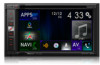
Pioneer AVIC-5100NEX Owner's Manual - Page 66
Warnings, settings, Navigation Map
 |
View all Pioneer AVIC-5100NEX manuals
Add to My Manuals
Save this manual to your list of manuals |
Page 66 highlights
Chapter 10 Customizing preferences of the navigation Announce System Messages When a system message appears, this navigation system can read out the message. "Warnings" settings IMPORTANT ! This system is able to warn you if you exceed the current speed limit. This information may not be available for your region (ask your local dealer), or may not be fully correct for all roads on the map. ! You are liable for ensuring that using this feature is legal in the country where you intend to use it. Speed Warning ! Warn When Speeding You can select whether you want to receive visible and/or audible warnings. The following alert types are available: - Audio and Visual: When selected, audi- ble and visible warnings will go off when you exceed the speed limit. - Visual: When selected, visible warnings will go off when you exceed the speed limit. ! Speed Limit Always Visible You can select whether you want to see the speed limit sign on the map all the time. When you set the speed limit to always be visible, the color of the speed limit sign changes when you exceed the speed limit. ! Warn at *** percent of the Speed Limit (Outside Cities) You can receive a warning when you reach the set percentage of the speed limit in rural areas. ! Warn at *** percent of the Speed Limit (in Cities) You can receive a warning when you reach the set percentage of the speed limit in urban areas. Alert Points This setting allows you to receive a warning when approaching alert points like school zones or railroad crossings. = For details, refer to Setting the alert point warnings on page 70. "Navigation Map" settings Map Display You can see the effect when you change a setting. ! Viewpoint You can adjust the basic zoom and tilt levels to your needs. Three levels are available. ! Color Mode You can switch between daytime and nighttime color modes or let the software switch between the two modes automatically a few minutes before sunrise and a few minutes after sunset. ! Day Map Color You can select the color scheme used in the daytime map. ! Night Map Color You can select the color scheme used in nighttime map. ! Landmarks This setting shows or hides 3D landmarks which are 3D artistic or block representations of prominent or well-known objects. p For AVIC-6100NEX and AVIC-5100NEX, this function becomes effective only when the additional map data is installed. ! Buildings This setting shows or hides 3D city models which are 3D artistic or block representations of complete city building data containing actual building sizes and actual positions on the map. p For AVIC-6100NEX and AVIC-5100NEX, this function becomes effective only when the additional map data is installed. 66 En
-
 1
1 -
2
-
3
-
4
-
5
-
6
-
7
-
8
-
9
-
10
-
11
-
12
-
13
-
14
-
15
-
16
-
17
-
18
-
19
-
20
-
21
-
22
-
23
-
24
-
25
-
26
-
27
-
28
-
29
-
30
-
31
-
32
-
33
-
34
-
35
-
36
-
37
-
38
-
39
-
40
-
41
-
42
-
43
-
44
-
45
-
46
-
47
-
48
-
49
-
50
-
51
-
52
-
53
-
54
-
55
-
56
-
57
-
58
-
59
-
60
-
 61
61 -
 62
62 -
 63
63 -
 64
64 -
 65
65 -
 66
66 -
 67
67 -
 68
68 -
 69
69 -
 70
70 -
 71
71 -
72
-
73
-
74
-
75
-
76
-
77
-
78
-
79
-
80
-
81
-
82
-
83
-
84
-
85
-
86
-
87
-
88
-
89
-
90
-
91
-
92
-
93
-
94
-
95
-
96
-
97
-
98
-
99
-
100
-
101
-
102
-
103
-
104
-
105
-
106
-
107
-
108
-
109
-
110
-
111
-
112
-
113
-
114
-
115
-
116
-
117
-
118
-
119
-
120
-
121
-
122
-
123
-
124
-
125
-
126
-
127
-
128
-
129
-
130
-
131
-
132
-
133
-
134
-
135
-
136
-
137
-
138
-
139
-
140
-
141
-
142
-
143
-
144
-
145
-
146
-
147
-
148
-
149
-
150
-
151
-
152
-
153
-
154
-
155
-
156
-
157
-
158
-
159
-
160
-
161
-
162
-
163
-
164
-
165
-
166
-
167
-
168
-
169
-
170
-
171
-
172
-
173
-
174
-
175
-
176
-
177
-
178
-
179
-
180
-
181
-
182
-
183
-
184
-
185
-
186
-
187
-
188
-
189
-
190
-
191
-
192
-
193
-
194
-
195
-
196
-
197
-
198
-
199
-
200
-
201
-
202
-
203
-
204
-
205
-
206
-
207
-
208
-
209
-
210
-
211
-
212
-
213
-
214
-
215
-
216
-
217
-
218
-
219
-
220
-
221
-
222
-
223
-
224
-
225
-
226
-
227
-
228
-
229
-
230
-
231
-
232
-
233
-
234
-
235
-
236
-
237
-
238
-
239
-
240
-
241
-
242
-
243
-
244
-
245
-
246
-
247
-
248
-
249
-
250
-
251
-
252
-
253
-
254
-
255
-
256
-
257
-
258
-
259
-
260
-
261
-
262
-
263
-
264
 |
 |